- Alternative title
-
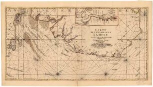
MAPA MARITIMO / DEL GOLFO DE MEXICO / E ISLAS DE LA AMERICA, / PARA EL USO DE LOS NAVEGANTES EN ESTA
- Location
-
Deutsches Historisches Museum, Berlin
- Inventory number
-
Do 2006/9.1-2
- Measurements
-
Höhe x Breite: 64 x 48,5 cm (Blatt 1)
Höhe x Breite: 53,5 x 37,5 cm (Karte 1)
Höhe x Breite: 57,5 x 40 cm (Platte 1)
Höhe x Breite: 63,5 x 49 cm (Blatt 2)
Höhe x Breite: 53,5 x 38,5 cm (Karte 2)
Höhe x Breite: 57,5 x 41 cm (Platte 2)
- Material/Technique
-
Druckfarbe, Papier, Kupferstich
- Classification
-
Kartografie (Gattung)
- Subject (what)
-
Südamerika
Westindische Inseln
- Event
-
Herstellung
- (who)
-
Kartograf, Kupferstecher: Tomás López de Vargas Machuca
Kartograf, Stecher: Juan de la Cruz Cano y Olmedilla
- (where)
-
Madrid, Spanien
- (when)
-
1755
- Rights
-
Deutsches Historisches Museum
- Last update
-
24.03.2023, 9:31 AM CET
Data provider
This object is provided by:
Stiftung Deutsches Historisches Museum. If you have any questions about the object, please contact the data provider.
Stiftung Deutsches Historisches Museum. If you have any questions about the object, please contact the data provider.
Object type
- Seekarte
Associated
- Kartograf, Kupferstecher: Tomás López de Vargas Machuca
- Kartograf, Stecher: Juan de la Cruz Cano y Olmedilla
Time of origin
- 1755
Other Objects (12)
Carte de l'Entrée de la Tamise
Seekarte
Golfe Persique
Seekarte
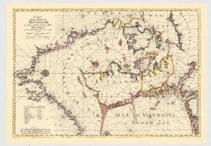
Contenant les Bancs, Passes, Isles et Costes depuis Norden et Le Cap Der-Neus jusque a Rostock et Valsterbon.- Carte de la Mer de Dannemark et des Entrées dans la Mer Baltique
Seekarte
![5e [Cinquième] Carte Particulière des Costes de Bretagne](https://iiif.deutsche-digitale-bibliothek.de/image/2/7c5d1e9d-4ade-45dd-808c-42e53ad87ea2/full/!306,450/0/default.jpg)
5e [Cinquième] Carte Particulière des Costes de Bretagne

Seekarte mit Routen der S.M.S. "Seeadler" 1909 - 1911
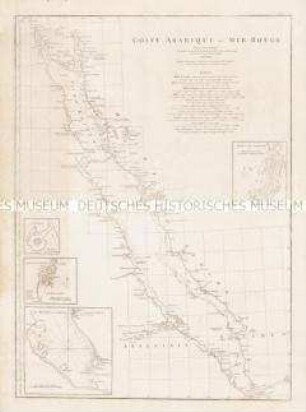
Golfe Arabique ou Mer Rouge. Mit 4 Nebenkarten: Port de Giddah; Suakem; Matzua et Arkiko; Al Babo (ou la Porte) et ses Environs.
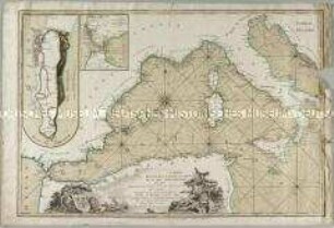
Carte Reduite de la Partie Occidentiale de la Mer Mediterranée. Mit zwei Nebenkarten: Plan de Gibraltar; Plan du Detroit de Gibraltar
![A Chart of the Eems Elve, Weser, Eyder, & Hever. With the Holy Island [Helgoland].](https://iiif.deutsche-digitale-bibliothek.de/image/2/d96178db-8096-4956-ab15-59053add2b29/full/!306,450/0/default.jpg)
A Chart of the Eems Elve, Weser, Eyder, & Hever. With the Holy Island [Helgoland].
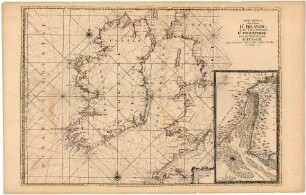
Carte Particulière des Costes d'Irlande et des Costes Occidentales d'Angleterre
Carte de l'Entrée de la Tamise
Seekarte
Golfe Persique
Seekarte
Contenant les Bancs, Passes, Isles et Costes depuis Norden et Le Cap Der-Neus jusque a Rostock et Valsterbon.- Carte de la Mer de Dannemark et des Entrées dans la Mer Baltique
Seekarte
5e [Cinquième] Carte Particulière des Costes de Bretagne
Seekarte mit Routen der S.M.S. "Seeadler" 1909 - 1911
Golfe Arabique ou Mer Rouge. Mit 4 Nebenkarten: Port de Giddah; Suakem; Matzua et Arkiko; Al Babo (ou la Porte) et ses Environs.
Carte Reduite de la Partie Occidentiale de la Mer Mediterranée. Mit zwei Nebenkarten: Plan de Gibraltar; Plan du Detroit de Gibraltar
A Chart of the Eems Elve, Weser, Eyder, & Hever. With the Holy Island [Helgoland].