Archivale
Tabula Geographica Nova Exhibens Partem Infra Monthanam Burggraviatus Norimbergensis sive Principatum Onolsbachensam Cum Terris Limitaneis Accurate Delineatum
- Reference number
-
K 213
- Context
-
D. 3. Karten und Pläne >> 3.3 Franken und Bayern
- Holding
-
K; Bpl D. 3. Karten und Pläne
- Other object pages
- Last update
-
30.06.2025, 12:36 PM CEST
Data provider
This object is provided by:
Stadtarchiv Fürth. If you have any questions about the object, please contact the data provider.
Stadtarchiv Fürth. If you have any questions about the object, please contact the data provider.
Object type
- Archivale
Other Objects (12)

Tabula Geographica Nora Exhibens Partem Infra Montanam Burggraviatus Norimbergensis Live Principatum Onolsbachensan Cum Terris Limttaneis Accurate Delineatum
Tabula Geographica Nova exhibens partem infra montanam Burggraviatus Norimbergensis sive Principatum Onolsbacensem ... .
![Tabula Geographica Nova Exhibens Partem Infra Montanam Burggraviatus Norimbergensis Sive Principatum Onolsbacensem Cum Terris Limitaneis Accurate Delineatam : [gewidmet] Wilhelmo Friderico Marchioni Brandenburgico](https://iiif.deutsche-digitale-bibliothek.de/image/2/86affacc-492c-4774-96d9-6cd80e2ee143/full/!306,450/0/default.jpg)
Tabula Geographica Nova Exhibens Partem Infra Montanam Burggraviatus Norimbergensis Sive Principatum Onolsbacensem Cum Terris Limitaneis Accurate Delineatam : [gewidmet] Wilhelmo Friderico Marchioni Brandenburgico
"Amplissima Collectio Documentorum Burggraviatus Norimbergensis Volumen II".
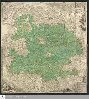
Tabula Geographica Nova Exhibens Partem Infra Montanam Burggraviatus Norimbergensis Sive Principatum Onolsbacensem Cum Terris Limitaneis Accurate Delineatam : Serenissimo Principi ac Domino, Domino Wilhelmo Friderico, Marchioni Brandenburgico ...
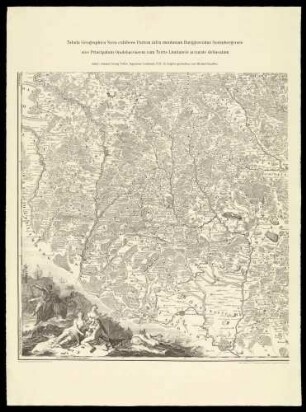
Tabula Geographica exhibens Partem infra montanam Burggraviatus Norimbergensis (Faksimile)
Nachlass Longolius Bd. 4,2: Inventarium Diplomaticum Historae Burggraviatus Norimbergensis
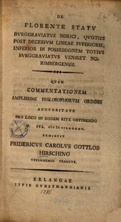
De florente statu Burggraviatus Norici, quoties post decessum lineae superioris, inferior in possessionem totius Burggraviatus veniret Norimbergensis
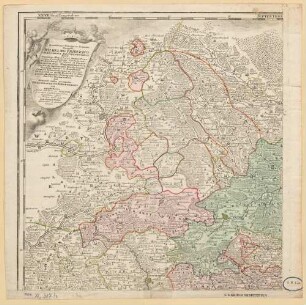
Tabula Geographica Nova Exhibens Partem Infra Montanam Burggraviatus Norimbergensis Sive Principatum Onolsbacensem Cum Terris Limitaneis Accurate Delineatam : Serenissimo Principi ac Domino, Domino Wilhelmo Friderico, Marchioni Brandenburgico, Duci Borussiae, Magdeburgi, Stettini, Pomeraniae, Cassubiorum, Vandalorum, Mecklenburgi, in Silesia et Crosnae ...

Heroem Philosophice delineatum
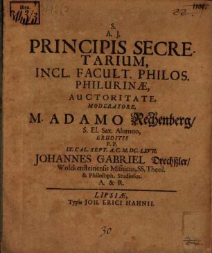
Principis secretarium delineatum
Principis secretarium delineatum
Tabula Geographica Nora Exhibens Partem Infra Montanam Burggraviatus Norimbergensis Live Principatum Onolsbachensan Cum Terris Limttaneis Accurate Delineatum
Tabula Geographica Nova exhibens partem infra montanam Burggraviatus Norimbergensis sive Principatum Onolsbacensem ... .
Tabula Geographica Nova Exhibens Partem Infra Montanam Burggraviatus Norimbergensis Sive Principatum Onolsbacensem Cum Terris Limitaneis Accurate Delineatam : [gewidmet] Wilhelmo Friderico Marchioni Brandenburgico
"Amplissima Collectio Documentorum Burggraviatus Norimbergensis Volumen II".
Tabula Geographica Nova Exhibens Partem Infra Montanam Burggraviatus Norimbergensis Sive Principatum Onolsbacensem Cum Terris Limitaneis Accurate Delineatam : Serenissimo Principi ac Domino, Domino Wilhelmo Friderico, Marchioni Brandenburgico ...
Tabula Geographica exhibens Partem infra montanam Burggraviatus Norimbergensis (Faksimile)
Nachlass Longolius Bd. 4,2: Inventarium Diplomaticum Historae Burggraviatus Norimbergensis
De florente statu Burggraviatus Norici, quoties post decessum lineae superioris, inferior in possessionem totius Burggraviatus veniret Norimbergensis
Tabula Geographica Nova Exhibens Partem Infra Montanam Burggraviatus Norimbergensis Sive Principatum Onolsbacensem Cum Terris Limitaneis Accurate Delineatam : Serenissimo Principi ac Domino, Domino Wilhelmo Friderico, Marchioni Brandenburgico, Duci Borussiae, Magdeburgi, Stettini, Pomeraniae, Cassubiorum, Vandalorum, Mecklenburgi, in Silesia et Crosnae ...
Heroem Philosophice delineatum
Principis secretarium delineatum
Principis secretarium delineatum
Tabula Geographica Nora Exhibens Partem Infra Montanam Burggraviatus Norimbergensis Live Principatum Onolsbachensan Cum Terris Limttaneis Accurate Delineatum
Tabula Geographica Nova exhibens partem infra montanam Burggraviatus Norimbergensis sive Principatum Onolsbacensem ... .
Tabula Geographica Nova Exhibens Partem Infra Montanam Burggraviatus Norimbergensis Sive Principatum Onolsbacensem Cum Terris Limitaneis Accurate Delineatam : [gewidmet] Wilhelmo Friderico Marchioni Brandenburgico
"Amplissima Collectio Documentorum Burggraviatus Norimbergensis Volumen II".
Tabula Geographica Nova Exhibens Partem Infra Montanam Burggraviatus Norimbergensis Sive Principatum Onolsbacensem Cum Terris Limitaneis Accurate Delineatam : Serenissimo Principi ac Domino, Domino Wilhelmo Friderico, Marchioni Brandenburgico ...
Tabula Geographica exhibens Partem infra montanam Burggraviatus Norimbergensis (Faksimile)
Nachlass Longolius Bd. 4,2: Inventarium Diplomaticum Historae Burggraviatus Norimbergensis
De florente statu Burggraviatus Norici, quoties post decessum lineae superioris, inferior in possessionem totius Burggraviatus veniret Norimbergensis
Tabula Geographica Nova Exhibens Partem Infra Montanam Burggraviatus Norimbergensis Sive Principatum Onolsbacensem Cum Terris Limitaneis Accurate Delineatam : Serenissimo Principi ac Domino, Domino Wilhelmo Friderico, Marchioni Brandenburgico, Duci Borussiae, Magdeburgi, Stettini, Pomeraniae, Cassubiorum, Vandalorum, Mecklenburgi, in Silesia et Crosnae ...
Heroem Philosophice delineatum
Principis secretarium delineatum