Karten und Pläne
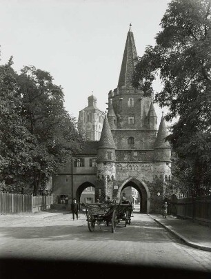
Titel: [Das Bartholomäer-Institut in Ingolstadt]. Art: Ansicht. Darstellungsmethode: Aufriss. Dargestellter räuml. Bereich: [Das Bartholomäer-Institut in Ingolstadt-Frontansicht]. Aussagen des zugehörigen Schriftguts: Ohne Zusammenhang mit dem Herkunftsfaszikel. Historisches Territorium: Stadt Ingolstadt. Modernes Territorium: Kreisfreie Stadt Ingolstadt
- Reference number
-
Plansammlung 20516/a
- Dimensions
-
27,0 x 38,3
- Formal description
-
Trägermaterial: Papier
Ausführung: braune Feder, laviert, grüne Wasserfarbe
- Context
-
Plansammlung >> Plansammlung
- Holding
-
Plansammlung
- Indexentry place
-
Ingolstadt (krfr.St.): Bartholomäer-Institut
- Date of creation
-
[Ende 17. Jh.] ([Ende 17. Jh. Bestand])
- Other object pages
- Last update
-
03.04.2025, 1:40 PM CEST
Data provider
This object is provided by:
Bayerisches Hauptstaatsarchiv. If you have any questions about the object, please contact the data provider.
Bayerisches Hauptstaatsarchiv. If you have any questions about the object, please contact the data provider.
Object type
- Karten und Pläne
Time of origin
- [Ende 17. Jh.] ([Ende 17. Jh. Bestand])
Other Objects (12)

Titel: Befestigungsplan von Ingolstadt. Art: Grundriss. Historisches Territorium: Stadt Ingolstadt. Modernes Territorium: Kreisfreie Stadt Ingolstadt
Art: Grundriss. Dargestellter räuml. Bereich: Erdgeschoss. Dargestelltes räuml. Thema: Umbau des Jesuitenkollegs Ingolstadt. Historisches Territorium: Stadt Ingolstadt. Modernes Territorium: Kreisfreie Stadt Ingolstadt
Art: Grundriss. Dargestellter räuml. Bereich: Erstes Stockwerk. Dargestelltes räuml. Thema: Umbau des Jesuitenkollegs Ingolstadt. Historisches Territorium: Stadt Ingolstadt. Modernes Territorium: Kreisfreie Stadt Ingolstadt
Ingolstadt : lieben Sie Ingolstadt?
Stadttheater Ingolstadt, 807 Ingolstadt
Titel: [Das Bartholomäer-Institut in Ingolstadt]. Art: Grundriss. Dargestellter räuml. Bereich: Erdgeschoss. Aussagen des zugehörigen Schriftguts: Ohne Zusammenhang mit dem Herkunftsfaszikel. Historisches Territorium: Stadt Ingolstadt. Modernes Territorium: Kreisfreie Stadt Ingolstadt
Ingolstadt : purgatório em Ingolstadt : tropa fandanga em Ingolstadt
Titel: [Das Bartholomäer-Institut in Ingolstadt]. Art: Grundriss. Dargestellter räuml. Bereich: 1. Stockwerk. Aussagen des zugehörigen Schriftguts: Ohne Zusammenhang mit dem Herkunftsfaszikel. Historisches Territorium: Stadt Ingolstadt. Modernes Territorium: Kreisfreie Stadt Ingolstadt
Titel: [Das Bartholomäer-Institut in Ingolstadt]. Art: Grundriss. Dargestellter räuml. Bereich: 2. Stockwerk. Aussagen des zugehörigen Schriftguts: Kein Zusammenhang mit dem Herkunftsfaszikel. Historisches Territorium: Stadt Ingolstadt. Modernes Territorium: Kreisfreie Stadt Ingolstadt
Titel: Plan, des ney gemessenen Donau Rinsall oberhalb Ingolstadt. Art: Grundriss. Maßstab: 200 Toises = 15,4 cm. Historisches Territorium: Stadt Ingolstadt. Modernes Territorium: Kreisfreie Stadt Ingolstadt
Wohnungsbaugesellschaft Ingolstadt GmbH, Ingolstadt
Ingolstadt, Kreuztor : Ingolstadt. Kreuztor. Deldseite
Titel: Befestigungsplan von Ingolstadt. Art: Grundriss. Historisches Territorium: Stadt Ingolstadt. Modernes Territorium: Kreisfreie Stadt Ingolstadt
Art: Grundriss. Dargestellter räuml. Bereich: Erdgeschoss. Dargestelltes räuml. Thema: Umbau des Jesuitenkollegs Ingolstadt. Historisches Territorium: Stadt Ingolstadt. Modernes Territorium: Kreisfreie Stadt Ingolstadt
Art: Grundriss. Dargestellter räuml. Bereich: Erstes Stockwerk. Dargestelltes räuml. Thema: Umbau des Jesuitenkollegs Ingolstadt. Historisches Territorium: Stadt Ingolstadt. Modernes Territorium: Kreisfreie Stadt Ingolstadt
Ingolstadt : lieben Sie Ingolstadt?
Stadttheater Ingolstadt, 807 Ingolstadt
Titel: [Das Bartholomäer-Institut in Ingolstadt]. Art: Grundriss. Dargestellter räuml. Bereich: Erdgeschoss. Aussagen des zugehörigen Schriftguts: Ohne Zusammenhang mit dem Herkunftsfaszikel. Historisches Territorium: Stadt Ingolstadt. Modernes Territorium: Kreisfreie Stadt Ingolstadt
Ingolstadt : purgatório em Ingolstadt : tropa fandanga em Ingolstadt
Titel: [Das Bartholomäer-Institut in Ingolstadt]. Art: Grundriss. Dargestellter räuml. Bereich: 1. Stockwerk. Aussagen des zugehörigen Schriftguts: Ohne Zusammenhang mit dem Herkunftsfaszikel. Historisches Territorium: Stadt Ingolstadt. Modernes Territorium: Kreisfreie Stadt Ingolstadt
Titel: [Das Bartholomäer-Institut in Ingolstadt]. Art: Grundriss. Dargestellter räuml. Bereich: 2. Stockwerk. Aussagen des zugehörigen Schriftguts: Kein Zusammenhang mit dem Herkunftsfaszikel. Historisches Territorium: Stadt Ingolstadt. Modernes Territorium: Kreisfreie Stadt Ingolstadt
Titel: Plan, des ney gemessenen Donau Rinsall oberhalb Ingolstadt. Art: Grundriss. Maßstab: 200 Toises = 15,4 cm. Historisches Territorium: Stadt Ingolstadt. Modernes Territorium: Kreisfreie Stadt Ingolstadt
Wohnungsbaugesellschaft Ingolstadt GmbH, Ingolstadt