Verzeichnung
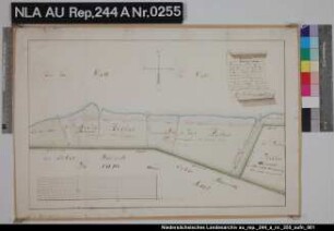
Lage von vermessenen Kolonatsgrundstücken im Sumpfland zwischen AYENWOLDE und Hatshausen Kolorierte Zeichnung von Northeim Papier Format 41,0x35,3 M 1:5.100
- Reference number
-
NLA HA, Rep. 244, A Nr. 189
- Former reference number
-
Rep. 244, 312 A
Rep. 244 A 312
- Further information
-
Ergänzungen: Klassifikation TeilB: Ayenwolde
- Context
-
Kartensammlung >> 5 Regierungsbezirk Weser-Ems >> 10 Kreis Leer >> 5 Feldmarken, Stadt- und Ortspläne, Flurstücke
- Holding
-
Rep. 244 Kartensammlung
- Indexentry person
-
Northeim
- Indexentry place
-
Ayenwolde, Kolonatsgrundstücke
Hatshausen, Kolonatsgrundstücke
- Date of creation
-
- 1772
- Other object pages
- Last update
-
16.06.2025, 1:30 PM CEST
Data provider
This object is provided by:
Niedersächsisches Landesarchiv. If you have any questions about the object, please contact the data provider.
Niedersächsisches Landesarchiv. If you have any questions about the object, please contact the data provider.
Object type
- Verzeichnung
Time of origin
- - 1772
Other Objects (12)
Lage des vermessenen und eingedeichten Mandeheller bei OSTERMARSCH Kolorierte Zeichnung von J. N. Franzius Papier Format 48,2x31,6 M 1:5.100

Vier vermessene Kolonatsgrundstücke im Nordwesten des Forstes HOPELS Kolorierte Zeichnung von W. van der Linden Papier Format 35,2x22,0 M 1:5.100

Vier vermessene Kolonatsgrundstücke im Nordwesten des Forstes HOPELS Kolorierte Zeichnung von W. van der Linden Papier Format 35,3x21,8 M 1:5.100
Lage von vermessenen Grundstücken der Addinggaster Sielacht bei ADDINGGASTE Kolorierte Zeichnung von F. W. Magott Papier Format 52,5x37,4 M 1:5.100

Das Timmel-Ostender Sumpfland- und Moorgebiet bei TIMMEL mit den Wegen und angrenzenden Ländereien Kolorierte Zeichnung von J. N. von Northeim Papier Format 39,0x30,2 M 1:5.100

Der vermessene Forst Tannenkamp bei SANDHORST mit den Wegen und angrenzenden Gebieten Zeichnung von W. van der Linden Papier Format 54,5x45,3 M 1:5.100

Das Uhlenmoor bei DUNUM mit den angrenzenden Kolonatsgrundstücken und Wegen Kolorierte Zeichnung von Börner Papier Format 43,0x30,6 M 1:5.100
15100-15199
Das Forstrevier IHLOW mit den einzelnen Waldflächen, Gebäuden, Wegen und Tiefen Kolorierte Zeichnung von C. E. Kuntze Papier Format 53,5x44,3 M 1:5.100
Das Nordmeer bei MÜNKEBOE mit den angrenzenden Moorgebieten und Kolonien Kolorierte Zeichnung von Gnaphaeus nach Conring Papier Format 65,8x46,0 M 1:5.100

Lage der Ortschaft LÜBBERTSFEHN Zeichnung von NN. Papier Format 37,5x32,0 M 1:5.100 (ca)
Blatt 15100 Tollmingen
Lage des vermessenen und eingedeichten Mandeheller bei OSTERMARSCH Kolorierte Zeichnung von J. N. Franzius Papier Format 48,2x31,6 M 1:5.100
Vier vermessene Kolonatsgrundstücke im Nordwesten des Forstes HOPELS Kolorierte Zeichnung von W. van der Linden Papier Format 35,2x22,0 M 1:5.100
Vier vermessene Kolonatsgrundstücke im Nordwesten des Forstes HOPELS Kolorierte Zeichnung von W. van der Linden Papier Format 35,3x21,8 M 1:5.100
Lage von vermessenen Grundstücken der Addinggaster Sielacht bei ADDINGGASTE Kolorierte Zeichnung von F. W. Magott Papier Format 52,5x37,4 M 1:5.100
Das Timmel-Ostender Sumpfland- und Moorgebiet bei TIMMEL mit den Wegen und angrenzenden Ländereien Kolorierte Zeichnung von J. N. von Northeim Papier Format 39,0x30,2 M 1:5.100
Der vermessene Forst Tannenkamp bei SANDHORST mit den Wegen und angrenzenden Gebieten Zeichnung von W. van der Linden Papier Format 54,5x45,3 M 1:5.100
Das Uhlenmoor bei DUNUM mit den angrenzenden Kolonatsgrundstücken und Wegen Kolorierte Zeichnung von Börner Papier Format 43,0x30,6 M 1:5.100
15100-15199
Das Forstrevier IHLOW mit den einzelnen Waldflächen, Gebäuden, Wegen und Tiefen Kolorierte Zeichnung von C. E. Kuntze Papier Format 53,5x44,3 M 1:5.100
Das Nordmeer bei MÜNKEBOE mit den angrenzenden Moorgebieten und Kolonien Kolorierte Zeichnung von Gnaphaeus nach Conring Papier Format 65,8x46,0 M 1:5.100
Lage der Ortschaft LÜBBERTSFEHN Zeichnung von NN. Papier Format 37,5x32,0 M 1:5.100 (ca)