Karte / Plan
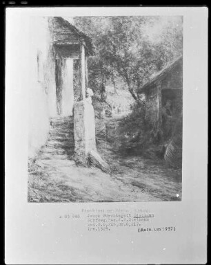
Karte vom Gebiet "Die Pöppelbrede" (zwischen dem Fahrweg nach dem Mindener Krug und dem Dorfweg um Brake gelegen; Amt Brake),. Inselkarte
- Reference number
-
D 73, 4/6624
- Dimensions
-
Höhe: 35, Breite: 45, Maßstab: ca. 1:1.930
- Context
-
Allgemeine Kartensammlung (bisherige Kartei) >> 22. Tit. 4 (noch nicht klassifiziert) >> 22.18. Nr. 6601 - 6800
- Holding
-
D 73 Allgemeine Kartensammlung (bisherige Kartei)
- Date of creation
-
(ca. 19. Jh.)
- Other object pages
- Provenance
-
Behörden, Institutionen, Einzelpersonen (Sammlungen)
- Delivered via
- Last update
-
05.11.2025, 4:23 PM CET
Data provider
This object is provided by:
Landesarchiv Nordrhein-Westfalen. Abteilung Ostwestfalen-Lippe. If you have any questions about the object, please contact the data provider.
Landesarchiv Nordrhein-Westfalen. Abteilung Ostwestfalen-Lippe. If you have any questions about the object, please contact the data provider.
Object type
- Karten / Pläne
Time of origin
- (ca. 19. Jh.)
Other Objects (12)

Neuer Krug zu Brake
Flurkarte der Lütterheide (Amt Brake),. Inselkarte
Karte der herrschaftlichen Meierei Brake;. Inselkarte
Karte vom Sporkholz (Amt Brake) Inselkarte
Karte des Mühlenbergs (Amt Brake),. Inselkarte
Dorfweg
Dorfweg
Dorfweg
Dorfweg
(Dorfweg)
Minder Krug (Münder Krug, Minderkrug) bei Brake
Brouillonkarte des Forstreviers Fahrenbreite (Amt Brake; Inselkarte
Neuer Krug zu Brake
Flurkarte der Lütterheide (Amt Brake),. Inselkarte
Karte der herrschaftlichen Meierei Brake;. Inselkarte
Karte vom Sporkholz (Amt Brake) Inselkarte
Karte des Mühlenbergs (Amt Brake),. Inselkarte
Dorfweg
Dorfweg
Dorfweg
Dorfweg
(Dorfweg)
Minder Krug (Münder Krug, Minderkrug) bei Brake