Karten und Pläne
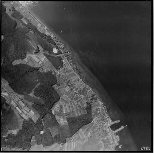
Bildflug 14.8.1988, Nr. 1347-32 - Luftaufnahme: Hindenburgkaserne, Waldgebiet Landkutschers Kapf
- Reference number
-
D 30/K 3270/7
- Former reference number
-
prefix: D 30/K
- Dimensions
-
66 x 84 cm
- Formal description
-
N: Reutlinger Straße/B28 / S: Landkutschers Kapf / O: Landkutschers Kapf / W: Hindenburgkaserne
- Material
-
Fotopapier
- Notes
-
2008/24, Zugang im Archiv 18.11.2008, Aktenabgabe des Stadtsanierungsamtes
- Further information
-
Ausführung: Foto (sw)
Maßstab: 1:1000
Druck / Verlag: Photogrammetrie GmbH München, Zweigstelle Südwest/Karlsruhe
- Context
-
D 30 Karten- und Plansammlung >> Luftaufnahmen
- Holding
-
D 30 Karten- und Plansammlung
- Indexbegriff subject
-
Hindenburgkaserne, Luftbild
Landkutschers Kapf
- Date of creation
-
14.08.1988
- Other object pages
- Last update
-
29.04.2025, 8:35 AM CEST
Data provider
This object is provided by:
Stadtarchiv Tübingen. If you have any questions about the object, please contact the data provider.
Stadtarchiv Tübingen. If you have any questions about the object, please contact the data provider.
Object type
- Karte und Plan
Time of origin
- 14.08.1988
Other Objects (12)

Hindenburgkaserne (Teilansicht), Landkutschers Kapf (Truppenübungsplatz der Franzosen); Luftbildaufnahme (Nr. 1347-32)
Bildflug 14.8.1988, Nr. 1347-30 - Luftaufnahme Südstadt: Stadtwerke Tübingen, Hindenburgkaserne
Bildflug 004, Streifen Oberschwaben 1954, Bildnummer 1347-1362
Hindenburgkaserne, Panzerhalle
Veränderungssperre Hindenburgkaserne
Bebauungsplan Hindenburgkaserne
Hindenburgkaserne, Sporthalle
Hindenburgkaserne, Panzerhalle
"Vranja, Hindenburgkaserne."
Bildflug 14.8.1988, Nr. 1347-30 - Luftaufnahme: Bergfriedhof, Schießstand im Schindhau, Galgenberg
Kapf

Kapf
Hindenburgkaserne (Teilansicht), Landkutschers Kapf (Truppenübungsplatz der Franzosen); Luftbildaufnahme (Nr. 1347-32)
Bildflug 14.8.1988, Nr. 1347-30 - Luftaufnahme Südstadt: Stadtwerke Tübingen, Hindenburgkaserne
Bildflug 004, Streifen Oberschwaben 1954, Bildnummer 1347-1362
Hindenburgkaserne, Panzerhalle
Veränderungssperre Hindenburgkaserne
Bebauungsplan Hindenburgkaserne
Hindenburgkaserne, Sporthalle
Hindenburgkaserne, Panzerhalle
"Vranja, Hindenburgkaserne."
Bildflug 14.8.1988, Nr. 1347-30 - Luftaufnahme: Bergfriedhof, Schießstand im Schindhau, Galgenberg
Kapf
Kapf
Hindenburgkaserne (Teilansicht), Landkutschers Kapf (Truppenübungsplatz der Franzosen); Luftbildaufnahme (Nr. 1347-32)
Bildflug 14.8.1988, Nr. 1347-30 - Luftaufnahme Südstadt: Stadtwerke Tübingen, Hindenburgkaserne
Bildflug 004, Streifen Oberschwaben 1954, Bildnummer 1347-1362
Hindenburgkaserne, Panzerhalle
Veränderungssperre Hindenburgkaserne
Bebauungsplan Hindenburgkaserne
Hindenburgkaserne, Sporthalle
Hindenburgkaserne, Panzerhalle
"Vranja, Hindenburgkaserne."
Bildflug 14.8.1988, Nr. 1347-30 - Luftaufnahme: Bergfriedhof, Schießstand im Schindhau, Galgenberg
Kapf