- Alternative title
-
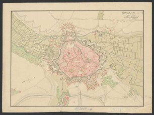
Plan / von / Valenciennes / nebst allen Lagern und
- Location
-
Deutsches Historisches Museum, Berlin
- Inventory number
-
Do 2006/746
- Measurements
-
Höhe x Breite: 37 x 49,2 cm (Blatt)
Höhe x Breite: 26 x 36,5 cm (Karte)
Höhe x Breite: 28,5 x 38,3 cm (Platte)
- Material/Technique
-
Papier, Kupferstich, koloriert
- Classification
-
Kartografie (Gattung)
- Subject (what)
-
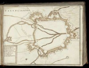
Valenciennes
Frankreich
- Event
-
Herstellung
- (who)
-
Verleger: Johann Gottlob Pech
- (where)
-
Frankfurt (Main), Deutschland
- (when)
-
um 1795
- Rights
-
Deutsches Historisches Museum
- Last update
-
24.03.2023, 9:28 AM CET
Data provider
This object is provided by:
Stiftung Deutsches Historisches Museum. If you have any questions about the object, please contact the data provider.
Stiftung Deutsches Historisches Museum. If you have any questions about the object, please contact the data provider.
Object type
- Belagerungskarte
Associated
- Verleger: Johann Gottlob Pech
Time of origin
- um 1795
Other Objects (12)

Plan de Valenciennes

Plan der franzoesischen Festung Valenciennes

Aktenverzeichnisse: Übungskursus Solesmes-Valenciennes, Übungsdivision Solesmes-Valenciennes, Übungsleitung Valenciennes
Valenciennes
Valenciennes

Valenciennes
[Valenciennes]
Valenciennes

Valenciennes.
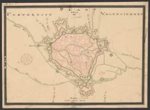
Plan de la forteresse de Valenciennes
Plan der Stadt und Zitadelle von Valenciennes

Valenciennes Spitze
Plan de Valenciennes
Plan der franzoesischen Festung Valenciennes
Aktenverzeichnisse: Übungskursus Solesmes-Valenciennes, Übungsdivision Solesmes-Valenciennes, Übungsleitung Valenciennes
Valenciennes
Valenciennes
Valenciennes
[Valenciennes]
Valenciennes
Valenciennes.
Plan de la forteresse de Valenciennes
Plan der Stadt und Zitadelle von Valenciennes