Verzeichnung
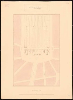
Situationsplan, Grund- und Aufriß für eine landwirtschaftliche Fortbildungsschule in Oldenburg 4 Blätter (davon Blatt b+c indentisch) Maßstab: 1:100 und 1:1000
- Reference number
-
NLA OL, K-ZE, Best. 298 OL A Nr. 877 a-d
- Further information
-
Identifikation: Band:
- Context
-
Zentraler Kartenbestand Oldenburg >> 5 Bezirksregierung Weser-Ems >> 5.19 Ehemaliger Verwaltungsbezirk Oldenburg bzw. dessen Vorgängerstaaten >> 5.19.7 Gebäude, Gebäudekomplexe, Ansichten, Grundrisse >> 5.19.7.1 Stadt Oldenburg >> 5.19.7.1.4 Ansichten und Bauzeichnungen vor dem Heiligengeisttor in Oldenburg
- Holding
-
NLA OL, K-ZE Zentraler Kartenbestand Oldenburg
- Indexentry place
-
Oldenburg, landwirtschaftliche Fortbildungsschule
- Date of creation
-
- 1900
- Other object pages
- Last update
-
16.06.2025, 11:09 AM CEST
Data provider
This object is provided by:
Niedersächsisches Landesarchiv. If you have any questions about the object, please contact the data provider.
Niedersächsisches Landesarchiv. If you have any questions about the object, please contact the data provider.
Object type
- Verzeichnung
Time of origin
- - 1900
Other Objects (12)
Hauptbahnhof, Frankfurt/Main: Situationsplan 1:1000
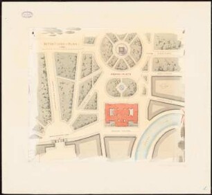
Reichstag, Berlin Zweiter Wettbewerb: Situationsplan 1:1000

Situationsplan vom Bahnhof in Heppens Maßstab: 1:1000
Situationsplan des Pfaffenlohgebietes. 1:1.000. H. Goerke (Verfasser)
Schule Reupzig, Schulneubau (- entwurf), Situationsplan (M 1:1.000)

Rheinwerk Mülhausen; Situationsplan des Einlaufes und Wehres 1:1000
Unteruhldingen, Meersburg: Situationsplan, Straßenprojekt Unteruhldingen - Meersburg, Maßstab: 1:1000
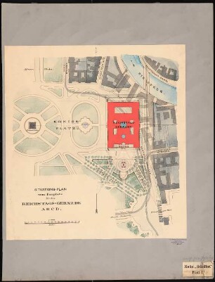
Reichstag, Berlin Zweiter Wettbewerb: Situationsplan vom Bauplatz 1:1000
Situationsplan (1:1000) eines Weingutes in Erdöbenye bei Tokay, Ungarn
Kaiser-Wilhelms-Universität Straßburg (Beilage I des Konkurrenzausschreibens): Situationsplan 1:1000
Krumbach, Sauldorf: Situationsplan II der Straßenkorrektion Krumbach - Sauldorf, Maßstab: 1:1000
Krumbach, Sauldorf: Situationsplan III der Straßenkorrektion Krumbach - Sauldorf, Maßstab: 1:1000
Hauptbahnhof, Frankfurt/Main: Situationsplan 1:1000
Reichstag, Berlin Zweiter Wettbewerb: Situationsplan 1:1000
Situationsplan vom Bahnhof in Heppens Maßstab: 1:1000
Situationsplan des Pfaffenlohgebietes. 1:1.000. H. Goerke (Verfasser)
Schule Reupzig, Schulneubau (- entwurf), Situationsplan (M 1:1.000)
Rheinwerk Mülhausen; Situationsplan des Einlaufes und Wehres 1:1000
Unteruhldingen, Meersburg: Situationsplan, Straßenprojekt Unteruhldingen - Meersburg, Maßstab: 1:1000
Reichstag, Berlin Zweiter Wettbewerb: Situationsplan vom Bauplatz 1:1000
Situationsplan (1:1000) eines Weingutes in Erdöbenye bei Tokay, Ungarn
Kaiser-Wilhelms-Universität Straßburg (Beilage I des Konkurrenzausschreibens): Situationsplan 1:1000
Krumbach, Sauldorf: Situationsplan II der Straßenkorrektion Krumbach - Sauldorf, Maßstab: 1:1000