Karte / Plan
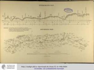
Nivellements- & Situationsplan des südlichen Düsselarmes von der Scheidlingsmühle bis zum Rhein
- Reference number
-
5-1-0 Plankammer, 5-1-0-1035.0000
- Former reference number
-
F 25, M 39, Nr. 181
- Dimensions
-
1780 x 889
- Formal description
-
Situationsplan vom Verlauf und Längsprofilzeichnung des südlichen Düsselarmes von der Scheidlingsmühle bis zum Rhein. Maßstab: Situationsplan 1:500, Profilzeichnung 1:3700, 1:3500, 1:4900, 1:978, 1:50.
- Material
-
Papier; auf Leinen
- Further information
-
Ausführung: Tuschzeichnung; Aquarell
Maßstab: 1:3700, 1:3500, 1:4900, 1:978, 1:50. 1:500
- Context
-
Plankammer >> Düsseldorf, gesamt >> Wasserbau >> Düssel
- Holding
-
5-1-0 Plankammer Plankammer
- Indexentry person
-
Kremer, Franz (1873 - 1875), Zeichner
- Date of creation
-
17.08.1882
- Other object pages
- Provenance
-
Wasserbau
- Delivered via
- Last update
-
17.09.2025, 3:28 PM CEST
Data provider
This object is provided by:
Stadtarchiv Düsseldorf. If you have any questions about the object, please contact the data provider.
Stadtarchiv Düsseldorf. If you have any questions about the object, please contact the data provider.
Object type
- Karten und Pläne
Time of origin
- 17.08.1882
Other Objects (12)

Linie Überlingen-Nußdorf-Mimmenhausen südlich des Mendlishauser Hofs: Situationsplan, Nivellements
Nivellements-Plan / Situations-Plan
Situationsplan vom südlichen Teil der königlichen Saline Schönebeck
Situationsplan von dem südlichen Theile des herzoglichen Parkes
Situationsplan vom südlichen Teil der königlichen Saline Schönebeck
Situationsplan von dem südlichen Theile des herzoglichen Parkes
Haltestelle Cauerwitz. Nivellements- und Situationsplan
Haltepunkt Waldau. Nivellements- und Situationsplan
Bahnhof Osterfeld. Nivellements- und Situationsplan
Zweigleisige Eisenbahnbrücke: Nivellements- und Situationsplan
Nivellements- und Situationsplan. Wasserletiung Hasselfelde
Bahnhof Schkölen. Nivellements- und Situationsplan
Linie Überlingen-Nußdorf-Mimmenhausen südlich des Mendlishauser Hofs: Situationsplan, Nivellements
Nivellements-Plan / Situations-Plan
Situationsplan vom südlichen Teil der königlichen Saline Schönebeck
Situationsplan von dem südlichen Theile des herzoglichen Parkes
Situationsplan vom südlichen Teil der königlichen Saline Schönebeck
Situationsplan von dem südlichen Theile des herzoglichen Parkes
Haltestelle Cauerwitz. Nivellements- und Situationsplan
Haltepunkt Waldau. Nivellements- und Situationsplan
Bahnhof Osterfeld. Nivellements- und Situationsplan
Zweigleisige Eisenbahnbrücke: Nivellements- und Situationsplan
Nivellements- und Situationsplan. Wasserletiung Hasselfelde