Karte / Plan
[Topographische Karte Belgiens:] Vielsalm. Levé et nivelé 1872. Dernière revision en 1903. Complèment en 1922 / Imp. litho. del'Institut Cartographique Militaire 1934. Directeur Cap. Ct. Pourceau. 2. Allée du Cloître Bruxelles.
- Former reference number
-
IV
- Dimensions
-
Maßstab: 1 : 40.000
- Notes
-
Auf Leinwand aufgezogen
- Context
-
RW Karten >> 1. Topographische Karten >> 1.3. Landesaufnahme Ausland >> 1.3.3. Europa >> 1.3.3.2. Belgien
- Holding
-
RW Karten
- Date of creation
-
1934
- Other object pages
- Provenance
-
Diverse Registraturbildner
- Delivered via
- Last update
-
17.09.2025, 2:41 PM CEST
Data provider
This object is provided by:
Landesarchiv Nordrhein-Westfalen. Abteilung Rheinland. If you have any questions about the object, please contact the data provider.
Landesarchiv Nordrhein-Westfalen. Abteilung Rheinland. If you have any questions about the object, please contact the data provider.
Object type
- Karten / Pläne
Time of origin
- 1934
Other Objects (12)

Venus dans le cloître, ou la religieuse en chemise

Venus Dans Le Cloitre, Ou La Religieuse En Chemise

Venus dans le cloître ou la religieuse en chemise
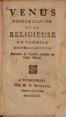
Venus dans le cloître ou la religieuse en chemise
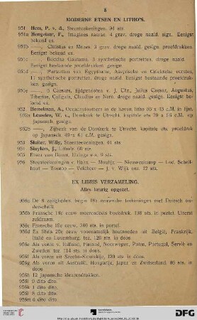
Moderne Etsen en Litho’s (Nr. 951-956)
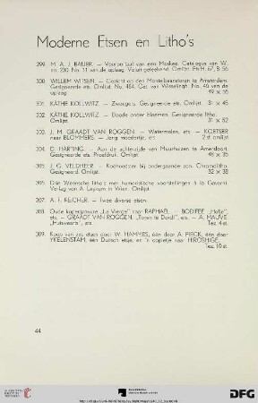
Moderne Etsen en Litho’s (Nr. 299-309)
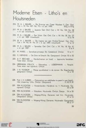
Moderne etsen - Litho's en houtsneden (Nr. 216-238)

"Litho"
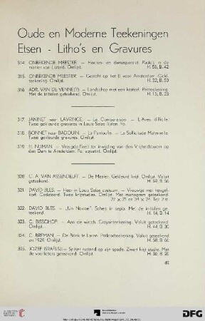
Oude en moderne teekeningen etsen – Litho’s en gravures (Nr. 314-347a)

Moderne teekeningen, etsen en litho’s (Nr. 818-884)

L' amant cloitré
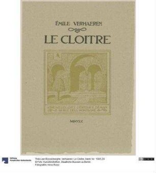
Verhaeren: Le Cloitre
Venus dans le cloître, ou la religieuse en chemise
Venus Dans Le Cloitre, Ou La Religieuse En Chemise
Venus dans le cloître ou la religieuse en chemise
Venus dans le cloître ou la religieuse en chemise
Moderne Etsen en Litho’s (Nr. 951-956)
Moderne Etsen en Litho’s (Nr. 299-309)
Moderne etsen - Litho's en houtsneden (Nr. 216-238)
"Litho"
Oude en moderne teekeningen etsen – Litho’s en gravures (Nr. 314-347a)
Moderne teekeningen, etsen en litho’s (Nr. 818-884)
L' amant cloitré