Karte / Plan
[Doppelstück zu 5200-5201]. Le Géometre du Cadastre / Der Katasterlandmesser Malmedy 20. Februar 1940. Nr. 61
- Reference number
-
RW Karten, 5202
- Notes
-
Leicht beschädigt.
- Context
-
RW Karten >> 8. Verkehr >> 8.1. (Land-)Wege und Straßen >> 8.1.2. Einzelne Landstraßen und Wege (und Netze)
- Holding
-
RW Karten
- Other object pages
- Provenance
-
Diverse Registraturbildner
- Delivered via
- Last update
-
17.09.2025, 3:28 PM CEST
Data provider
This object is provided by:
Landesarchiv Nordrhein-Westfalen. Abteilung Rheinland. If you have any questions about the object, please contact the data provider.
Landesarchiv Nordrhein-Westfalen. Abteilung Rheinland. If you have any questions about the object, please contact the data provider.
Object type
- Karten / Pläne
Other Objects (12)

Geometre

5201

CLXVI. Aigle & géometre

Geometre Tav. 43.
5200
5201. - 5250.

TGL 5201
Arbeitsbuch CABRI Géomètre, Buch.
NW 52/01 - 11 NO 52/01 - 02
Qu 5201-5399
Blatt 5201 Orsbach
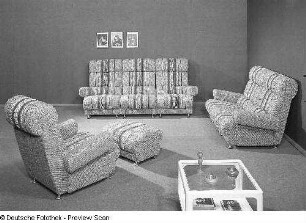
Sitzgruppe (Modell 5201)
Geometre
5201
CLXVI. Aigle & géometre
Geometre Tav. 43.
5200
5201. - 5250.
TGL 5201
Arbeitsbuch CABRI Géomètre, Buch.
NW 52/01 - 11 NO 52/01 - 02
Qu 5201-5399
Blatt 5201 Orsbach
Sitzgruppe (Modell 5201)
Geometre
5201
CLXVI. Aigle & géometre
Geometre Tav. 43.
5200
5201. - 5250.
TGL 5201
Arbeitsbuch CABRI Géomètre, Buch.
NW 52/01 - 11 NO 52/01 - 02
Qu 5201-5399
Blatt 5201 Orsbach