Topografische
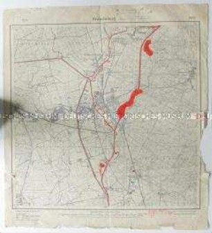
Topografische Karte aus dem 1. Weltkrieg mit der Umgebung von Verdun
- Alternative title
-
Verdun 35 A.
- Location
-
Deutsches Historisches Museum, Berlin
- Inventory number
-
DG 90/10982
- Measurements
-
Höhe x Breite: 31 x 46,8 cm
- Material/Technique
-
Papier, gedruckt
- Classification
-
Kartografie (Gattung)
- Subject (what)
-
Weltkrieg, 1.
Verdun
- Event
-
Herstellung
- (where)
-
Deutschland [historisch: Deutsches Reich]
- (when)
-
1914
- Rights
-
Deutsches Historisches Museum
- Last update
-
24.03.2023, 9:27 AM CET
Data provider
This object is provided by:
Stiftung Deutsches Historisches Museum. If you have any questions about the object, please contact the data provider.
Stiftung Deutsches Historisches Museum. If you have any questions about the object, please contact the data provider.
Object type
- Topografische
Time of origin
- 1914
Other Objects (12)

Topografische Karte von Paris und Umgebung aus dem 1. Weltkrieg
![[Topografische Karte] Umgebung von Krefeld](/assets/placeholder/searchResultMediaNoDigitisedMedia.png)
[Topografische Karte] Umgebung von Krefeld
Topografische Karte Karlsruhe und Umgebung
Topografische Karte der Umgebung Paderborns
[Topografische Karte Umgebung von Krefeld]
[Topografische Karte Moers und Umgebung]
Topografische Karte aus dem 1. Weltkrieg mit der Stadt Reims und Umgebung
Topografische Landesvermessung; Ausstellung topografischer Karten
Topografische Karte von Stettin und Umgebung
Topografische Karte von Oranienburg und Umgebung
Topografische Karte von Oebisfelde und Umgebung
Topografische Karte von Zossen und Umgebung
Topografische Karte von Paris und Umgebung aus dem 1. Weltkrieg
[Topografische Karte] Umgebung von Krefeld
Topografische Karte Karlsruhe und Umgebung
Topografische Karte der Umgebung Paderborns
[Topografische Karte Umgebung von Krefeld]
[Topografische Karte Moers und Umgebung]
Topografische Karte aus dem 1. Weltkrieg mit der Stadt Reims und Umgebung
Topografische Landesvermessung; Ausstellung topografischer Karten
Topografische Karte von Stettin und Umgebung
Topografische Karte von Oranienburg und Umgebung
Topografische Karte von Oebisfelde und Umgebung