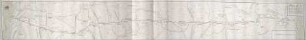
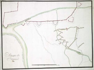
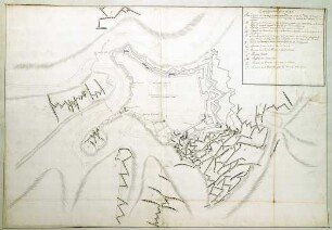
Karte/Plan
WHK 1 Einzelne kriegerische Vorfälle: Befestigte Linie vom Fluss Lys bis zur Mühle De Terluckle
- Archivaliensignatur
-
WHK 1/44
- Maße
-
1928 x 406 mm
- Sonstige Erschließungsangaben
-
Identifikation (Karte/Plan): Originaltitel: Plan Du Retranchement, Commencant a la riviere Du Lys jusques au moullain De Terluckle pres D' ottiguies comence l' ouvrage Du Tourmesis
Weitere Angaben (Karte/Plan): Maßstab: 200 th = 7,4 cm [1:5.200]
Weitere Angaben (Karte/Plan): Ausführung: Handzeichnung, farbig
Weitere Angaben (Karte/Plan): Blattzahl: 1
- Kontext
-
Wilhelmshöher Kriegskarten >> Einzelne Kriege und Schlachtordnungen >> WHK 1 Einzelne kriegerische Vorfälle
- Bestand
-
WHK Wilhelmshöher Kriegskarten
- Laufzeit
-
[1770-1790]
- Weitere Objektseiten
- Letzte Aktualisierung
-
10.06.2025, 09:13 MESZ
Datenpartner
Dieses Objekt wird bereitgestellt von:
Hessisches Staatsarchiv Marburg. Bei Fragen zum Objekt wenden Sie sich bitte an den Datenpartner.
Hessisches Staatsarchiv Marburg. Bei Fragen zum Objekt wenden Sie sich bitte an den Datenpartner.
Objekttyp
- Karte/Plan
Entstanden
- [1770-1790]
Ähnliche Objekte (12)
WHK 1 Einzelne kriegerische Vorfälle: Befestigte Linie zwischen Schelde und Leie (Lys), erbaut im November 1683
WHK 1 Einzelne kriegerische Vorfälle: Index zu "Einzelne kriegerische Vorfälle"
WHK 1 Einzelne kriegerische Vorfälle: Angriff von Courtrai
WHK 1 Einzelne kriegerische Vorfälle: Belagerung von Braunschweig, 1671
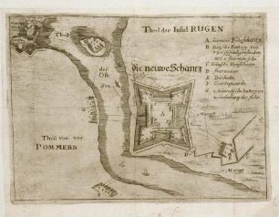
WHK 1 Einzelne kriegerische Vorfälle: Schlacht um Rügen, 1678
WHK 1 Einzelne kriegerische Vorfälle: Angriff auf Gerona, 1684
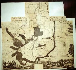
WHK 1 Einzelne kriegerische Vorfälle: Belagerung von Münster, 1661
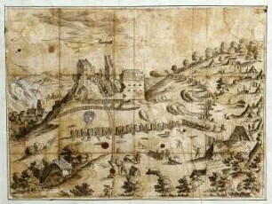
WHK 1 Einzelne kriegerische Vorfälle: Belagerung von Landstuhl, 1523
WHK 1 Einzelne kriegerische Vorfälle: Belagerung von Luxemburg, 1684
WHK 1 Einzelne kriegerische Vorfälle: Belagerung von Guilliers, 1610
WHK 1 Einzelne kriegerische Vorfälle: Belagerung von Gibraltar, 1779
WHK 1 Einzelne kriegerische Vorfälle: Belagerung von Luxemburg, 1684
WHK 1 Einzelne kriegerische Vorfälle: Befestigte Linie zwischen Schelde und Leie (Lys), erbaut im November 1683
WHK 1 Einzelne kriegerische Vorfälle: Index zu "Einzelne kriegerische Vorfälle"
WHK 1 Einzelne kriegerische Vorfälle: Angriff von Courtrai
WHK 1 Einzelne kriegerische Vorfälle: Belagerung von Braunschweig, 1671
WHK 1 Einzelne kriegerische Vorfälle: Schlacht um Rügen, 1678
WHK 1 Einzelne kriegerische Vorfälle: Angriff auf Gerona, 1684
WHK 1 Einzelne kriegerische Vorfälle: Belagerung von Münster, 1661
WHK 1 Einzelne kriegerische Vorfälle: Belagerung von Landstuhl, 1523
WHK 1 Einzelne kriegerische Vorfälle: Belagerung von Luxemburg, 1684
WHK 1 Einzelne kriegerische Vorfälle: Belagerung von Guilliers, 1610
WHK 1 Einzelne kriegerische Vorfälle: Belagerung von Gibraltar, 1779