Karte / Plan
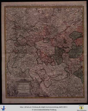
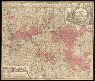
Mainz (Kurfürstentum) Fränkischer Kreis, westlicher Teil Territorialkarte Electoratus Moguntinus ut et Palatin: infer. Hassiae et fluminis Moeni aliqua pars 1.H. 18.Jh. 3 dt. Meilen = 6,15 cm 53 x 46 farb. Kupferstich: Joh. Baptist Homann B I Nr. 15
- Former reference number
-
B I 15
- Further information
-
Ort: Kurfürstentum Mainz
- Context
-
Karten A (Allgemein) >> 1. Topographische Karte, Übersichtskarten >> 1.3. Territorialkarten
- Holding
-
W 051 Karten A (Allgemein)
- Indexentry place
-
Kurfürstentum Mainz
Fränkischer Kreis, Territorialkarte s. Mainz, 1725
Main s. Mainz, 1725
Mainz, Kurfürstentum, Territorialkarte, 1725
Niederhessen, Territorialkarte s. Mainz, 1725
Pfalz, Territorialkarte s. Mainz, 1725
- Date of creation
-
1725
- Other object pages
- Provenance
-
Sammlungsregistraturbildner
- Delivered via
- Last update
-
05.11.2025, 4:26 PM CET
Data provider
This object is provided by:
Landesarchiv Nordrhein-Westfalen. Abteilung Westfalen. If you have any questions about the object, please contact the data provider.
Landesarchiv Nordrhein-Westfalen. Abteilung Westfalen. If you have any questions about the object, please contact the data provider.
Object type
- Karten / Pläne
Time of origin
- 1725
Other Objects (12)
Electoratus Moguntinus ut et Palatin: Infer. Hassiae

Franken "Electoratus Moguntinus et Palatin: Infer. Hassiae" - "Fränckischer Craisse"
Electoratus Moguntinus : ut et Palatin. Infer. Hassiae & Fluminis Moeni aliqua pars exhibens simul Occid. Circ. Franconiae partes nimiru insimam part. Episc. Würtz. Comit. Werth. Reineck, Hohenl. & Erpach etc. Geogr. exhibitus
[Territorialkarte 15. bis 18. Jahrhundert]
Liber ordinarius Moguntinus

Eminentissimus Elector Moguntinus
Bonifatius ep. Moguntinus
Bonifatius ep. Moguntinus
Archiepiscopatus et Electoratus Moguntinus
Rudolfus Salmann, Cammerarius Moguntinus
Salmannus, Judex Saecularis Moguntinus
Rudolfus Salmann, Cammerarius Moguntinus
Electoratus Moguntinus ut et Palatin: Infer. Hassiae
Franken "Electoratus Moguntinus et Palatin: Infer. Hassiae" - "Fränckischer Craisse"
Electoratus Moguntinus : ut et Palatin. Infer. Hassiae & Fluminis Moeni aliqua pars exhibens simul Occid. Circ. Franconiae partes nimiru insimam part. Episc. Würtz. Comit. Werth. Reineck, Hohenl. & Erpach etc. Geogr. exhibitus
[Territorialkarte 15. bis 18. Jahrhundert]
Liber ordinarius Moguntinus
Eminentissimus Elector Moguntinus
Bonifatius ep. Moguntinus
Bonifatius ep. Moguntinus
Archiepiscopatus et Electoratus Moguntinus
Rudolfus Salmann, Cammerarius Moguntinus
Salmannus, Judex Saecularis Moguntinus