Archivale
Lageplan des Grundstücks Monbijou-Platz 10
Enthält: Ecke Überfahrtsgasse mit Flächenangabe.
Kolorierte Handzeichnung auf Pausleinen
- Reference number
-
F Rep. 270 Nr. 10147
- Extent
-
1 : 500
- Further information
-
Format: 23 x 31,5 cm
- Context
-
F Rep. 270 Allgemeine Kartensammlung >> 07. Monbijouplatz (Mitte)
- Holding
-
F Rep. 270 Allgemeine Kartensammlung
- Date of creation
-
[um 1900]
- Other object pages
- Provenance
-
Abgabe Hr. Heinemann
- Rights
-
Für nähere Informationen zu Nutzungs- und Verwertungsrechten kontaktieren Sie bitte info@landesarchiv.berlin.de.
- Last update
-
22.08.2025, 12:07 PM CEST
Data provider
This object is provided by:
Landesarchiv Berlin. If you have any questions about the object, please contact the data provider.
Landesarchiv Berlin. If you have any questions about the object, please contact the data provider.
Object type
- Archivale
Time of origin
- [um 1900]
Other Objects (12)
![[Lageplan Schloßpark Monbijou]](/assets/placeholder/searchResultMediaNoDigitisedMedia.png)
[Lageplan Schloßpark Monbijou]
Grundzins des Grundstücks Monbijou-Platz 4
Grundzins des Grundstücks Monbijou-Platz 5, Oranienburger Straße 82
Monbijou
Monbijou

Schlößchen Monbijou
Schloß Monbijou
Schloss Monbijou

Modefrisur "Monbijou".
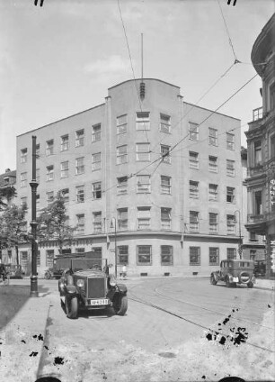
Bürohaus Monbijou

VI. Monbijou
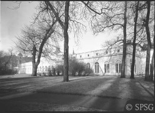
Monbijou, Aussenansicht
[Lageplan Schloßpark Monbijou]
Grundzins des Grundstücks Monbijou-Platz 4
Grundzins des Grundstücks Monbijou-Platz 5, Oranienburger Straße 82
Monbijou
Monbijou
Schlößchen Monbijou
Schloß Monbijou
Schloss Monbijou
Modefrisur "Monbijou".
Bürohaus Monbijou
VI. Monbijou
Monbijou, Aussenansicht
[Lageplan Schloßpark Monbijou]
Grundzins des Grundstücks Monbijou-Platz 4
Grundzins des Grundstücks Monbijou-Platz 5, Oranienburger Straße 82
Monbijou
Monbijou
Schlößchen Monbijou
Schloß Monbijou
Schloss Monbijou
Modefrisur "Monbijou".
Bürohaus Monbijou
VI. Monbijou