Karte / Plan
[Topografische Karte des Gebietes links der Maas mit Helmond, Eindhoven, Loemel, Roermond, Venlo, Weert]
- Reference number
-
836
- Dimensions
-
910 x 560
- Further information
-
Standort: 12.03
Ausführung: Stich
Maßstab: [1 : 100 000]
- Context
-
Karten und Pläne Stadt Kempen >> Kempen >> Territorien, Ämter, größere Gebiete, fremde Orte
- Holding
-
S 2b Karten und Pläne Stadt Kempen Karten und Pläne Stadt Kempen
- Indexentry person
-
Dupuis, L. A., Stecher
- Date of creation
-
[18. Jh.]
- Other object pages
- Delivered via
- Last update
-
05.11.2025, 3:28 PM CET
Data provider
This object is provided by:
Kreisarchiv Viersen. If you have any questions about the object, please contact the data provider.
Kreisarchiv Viersen. If you have any questions about the object, please contact the data provider.
Object type
- Karten und Pläne
Time of origin
- [18. Jh.]
Other Objects (12)
![Bl. XXXIV: Le Brabant Hollandois et Autrichien. [Gebiet um Roermond, Venlo, Gennep, 's-Hertigenbosch, Eindhoven, Helmond, Weert].](/assets/placeholder/searchResultMediaNoDigitisedMedia.png)
Bl. XXXIV: Le Brabant Hollandois et Autrichien. [Gebiet um Roermond, Venlo, Gennep, 's-Hertigenbosch, Eindhoven, Helmond, Weert].
Anlage VIII zum Kriegstagebuch.- Stellungskarte Raum Roermond - Eindhoven
Roermond statt Venlo: Wandern Dealer ab?
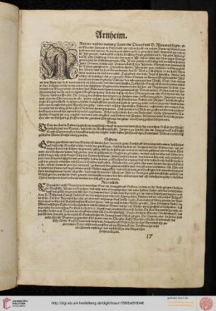
Arnheim (Arnheim), Venlo, Geldern, Ruermundt (Roermond)
[4 befestigte Städte: Arnheim, Venlo, Geldern, Roermond.]
Stadtpläne von Arnheim, Venlo, Geldern und Roermond
Weert
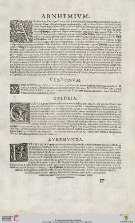
Arnhemium (Arnheim) / Venlonum (Venlo) / Geldria (Gelderland) / Ruremunda (Roermond)
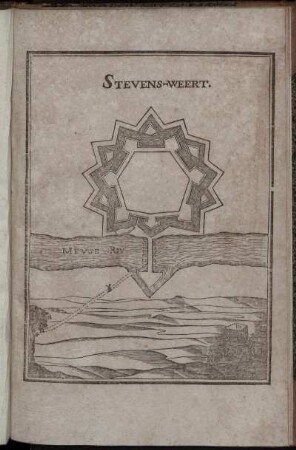
Stevens-weert
Pastoor, Weert
Oberquartier Geldern oder die Umgebung von Geldern, Venlo und Roermond
Oberquartier Geldern oder die Umgebung von Geldern, Venlo und Roermond
Bl. XXXIV: Le Brabant Hollandois et Autrichien. [Gebiet um Roermond, Venlo, Gennep, 's-Hertigenbosch, Eindhoven, Helmond, Weert].
Anlage VIII zum Kriegstagebuch.- Stellungskarte Raum Roermond - Eindhoven
Roermond statt Venlo: Wandern Dealer ab?
Arnheim (Arnheim), Venlo, Geldern, Ruermundt (Roermond)
[4 befestigte Städte: Arnheim, Venlo, Geldern, Roermond.]
Stadtpläne von Arnheim, Venlo, Geldern und Roermond
Weert
Arnhemium (Arnheim) / Venlonum (Venlo) / Geldria (Gelderland) / Ruremunda (Roermond)
Stevens-weert
Pastoor, Weert
Oberquartier Geldern oder die Umgebung von Geldern, Venlo und Roermond