- Reference number
-
D 30/K 2698
- Former reference number
-
prefix: D 30/K
- Dimensions
-
102 x 35,7 cm
- Material
-
Papier
- Notes
-
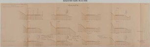
Einzeichnung des Wasserspiegels
- Further information
-
Ausführung: Lichtpause
Maßstab: 1:100
Druck / Verlag: Städtisches Tiefbauamt
- Context
-
D 30 Karten- und Plansammlung >> Wasserbauwesen an Neckar, Ammer und Steinlach
- Holding
-
D 30 Karten- und Plansammlung
- Indexbegriff subject
-
Neckar, Querprofil
- Date of creation
-
September 1906-Januar 1907
- Other object pages
- Last update
-
29.04.2025, 8:35 AM CEST
Data provider
This object is provided by:
Stadtarchiv Tübingen. If you have any questions about the object, please contact the data provider.
Stadtarchiv Tübingen. If you have any questions about the object, please contact the data provider.
Object type
- Karte und Plan
Time of origin
- September 1906-Januar 1907
Other Objects (12)

Querprofile von 87 + 00 bis 91 + 00
00 00; 00 00 01; 00 00 02; 00 00 03; 00 00 04; 00 00 05; 00 00 06; 00 00 07; 00 01 01; 00 03 00
Querprofile am rechten Ufer unterhalb des Kraftwerkskanals Profil + 15,00 bis + 56,00
Gleisanschluss Geldmacher, Querprofile, km 0,0 - 1,1
Film: 02/0033; 00/0575; 01/0272; 02/0065; 00/0592; 00/0593; 05/2213; 01/0287; 00/0629; 00/0611; 00/0618; 00/0631; 00/0640; 00/0627; 00/0642; 00/0651; 00/0660
Strecke Leipzig - Hof. Querprofile von Stat. 39+00 bis 40+00. Blatt 17. Berichtigte Entwurfszeichnung
Einbau eines Luftschutzraums beim Dienstwohngebäude - Querprofile von - 3,00 m bis + 21,00 m - Längenprofil
Filme 00/0614; 00/0658; 00/0641; 00/0644; 00/0656; 02/0131
Filme 00/0614; 00/0658; 00/0641; 00/0644; 00/0656; 02/0131
Front- und Überkopflader Z.-Nr.: P 44 - 00/00. Reihenkolbenpumpe 25 TGL 25-14705 Z.-Nr.: 206.1-00/00
Stellenakte 00/2.4 (00/1.4, 00/20.4)
00/061; 00/0680; 00/0672; 02/0170; 00/0690; 02/0153
Querprofile von 87 + 00 bis 91 + 00
00 00; 00 00 01; 00 00 02; 00 00 03; 00 00 04; 00 00 05; 00 00 06; 00 00 07; 00 01 01; 00 03 00
Querprofile am rechten Ufer unterhalb des Kraftwerkskanals Profil + 15,00 bis + 56,00
Gleisanschluss Geldmacher, Querprofile, km 0,0 - 1,1
Film: 02/0033; 00/0575; 01/0272; 02/0065; 00/0592; 00/0593; 05/2213; 01/0287; 00/0629; 00/0611; 00/0618; 00/0631; 00/0640; 00/0627; 00/0642; 00/0651; 00/0660
Strecke Leipzig - Hof. Querprofile von Stat. 39+00 bis 40+00. Blatt 17. Berichtigte Entwurfszeichnung
Einbau eines Luftschutzraums beim Dienstwohngebäude - Querprofile von - 3,00 m bis + 21,00 m - Längenprofil
Filme 00/0614; 00/0658; 00/0641; 00/0644; 00/0656; 02/0131
Filme 00/0614; 00/0658; 00/0641; 00/0644; 00/0656; 02/0131
Front- und Überkopflader Z.-Nr.: P 44 - 00/00. Reihenkolbenpumpe 25 TGL 25-14705 Z.-Nr.: 206.1-00/00
Stellenakte 00/2.4 (00/1.4, 00/20.4)