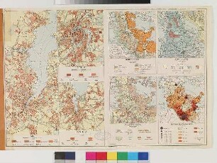
Stadtplan
Sechsteilige topografische Karte von Antwerpen und Umgebung vom Beginn des Ersten Weltkrieges
- Alternative title
-
Carte Speciale des Environs D'Anvers
- Location
-
Deutsches Historisches Museum, Berlin
- Inventory number
-
Do2 2016/2003
- Measurements
-
Höhe x Breite: 50,4 x 67,4 cm (je)
- Material/Technique
-
Papier, gedruckt
- Classification
-
Kartografie (Gattung)
- Subject (what)
-
Weltkrieg, 1.
Antwerpen
- Event
-
Herstellung
- (where)
-
Anvers, Belgien ?
- (when)
-
1914
- Rights
-
Deutsches Historisches Museum
- Last update
-
24.03.2023, 9:28 AM CET
Data provider
This object is provided by:
Stiftung Deutsches Historisches Museum. If you have any questions about the object, please contact the data provider.
Stiftung Deutsches Historisches Museum. If you have any questions about the object, please contact the data provider.
Object type
- Stadtplan
Time of origin
- 1914
Other Objects (12)

Topografische Karte des westlichen Teils von Berlin
Topografische Übersicht von Brügge mit den vier Stadttoren
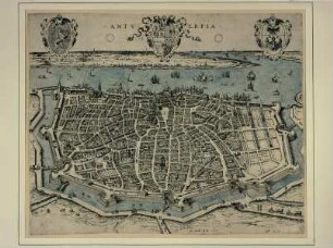
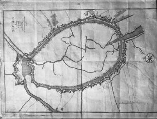
Stadtplan von Antwerpen

Stadtplan von Antwerpen
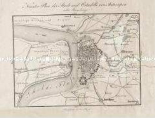
Neuester Plan der Stadt und Citadelle von Antwerpen nebst Umgebung
Karte von Stettin
Karte von Schleswig-Holstein und drei Städten
![Stadtplan und Ansicht von Kassel, ca. 1:5 000, Kupferst., 1742 : Plan der Hochfürstl. Residenz- und Haubt-Stadt Cassel in Nieder-Hessen : nebst dem Hochfürstl. Lust-Garten auf der Aue = Plan de la Ville Capitale de Cassel en basse Hesse / herausgeben von Homaennischen Erben. Revidirt von Leopold. - Rev.. - [Ca. 1:5 000]. - [Nürnberg] : Homaennischen Erben , 1742. - 1 Kt. + 1 Ansicht auf 1 Bl. : kolor. Kupferst. ; Gesamtgr. 56 x 50 cm](https://iiif.deutsche-digitale-bibliothek.de/image/2/b83bff86-49f8-49f5-8622-3b0444dc4c77/full/!306,450/0/default.jpg)
Stadtplan und Ansicht von Kassel, ca. 1:5 000, Kupferst., 1742 : Plan der Hochfürstl. Residenz- und Haubt-Stadt Cassel in Nieder-Hessen : nebst dem Hochfürstl. Lust-Garten auf der Aue = Plan de la Ville Capitale de Cassel en basse Hesse / herausgeben von Homaennischen Erben. Revidirt von Leopold. - Rev.. - [Ca. 1:5 000]. - [Nürnberg] : Homaennischen Erben , 1742. - 1 Kt. + 1 Ansicht auf 1 Bl. : kolor. Kupferst. ; Gesamtgr. 56 x 50 cm
![Pharus-Plan Stuttgart und Cannstatt : [Mit 1 Nebenkt.]](/assets/placeholder/searchResultMediaNoDigitisedMedia.png)
Pharus-Plan Stuttgart und Cannstatt : [Mit 1 Nebenkt.]

Athen, Nordabhang der Akropolis
Städteatlas Grossraum Stuttgart, Mittlerer Neckar : 1:20.000 ; mit Postleitzahlen ; 190 Städte und Gemeinden im Grossraum Stuttgart ; von Neckarsulm bis Reutlingen - von Pforzheim bis Göppingen ; Ausflugskarten: Nordschwarzwald, Schwäbische Alb
Russischer Stadtplan von Sankt Petersburg mit den Stadtteilen Wassilij Ostrow, Peterburgskij Ostrow und Admiralitätsteil
Topografische Karte des westlichen Teils von Berlin
Topografische Übersicht von Brügge mit den vier Stadttoren
Stadtplan von Antwerpen
Stadtplan von Antwerpen
Neuester Plan der Stadt und Citadelle von Antwerpen nebst Umgebung
Karte von Stettin
Karte von Schleswig-Holstein und drei Städten
Stadtplan und Ansicht von Kassel, ca. 1:5 000, Kupferst., 1742 : Plan der Hochfürstl. Residenz- und Haubt-Stadt Cassel in Nieder-Hessen : nebst dem Hochfürstl. Lust-Garten auf der Aue = Plan de la Ville Capitale de Cassel en basse Hesse / herausgeben von Homaennischen Erben. Revidirt von Leopold. - Rev.. - [Ca. 1:5 000]. - [Nürnberg] : Homaennischen Erben , 1742. - 1 Kt. + 1 Ansicht auf 1 Bl. : kolor. Kupferst. ; Gesamtgr. 56 x 50 cm
Pharus-Plan Stuttgart und Cannstatt : [Mit 1 Nebenkt.]
Athen, Nordabhang der Akropolis
Städteatlas Grossraum Stuttgart, Mittlerer Neckar : 1:20.000 ; mit Postleitzahlen ; 190 Städte und Gemeinden im Grossraum Stuttgart ; von Neckarsulm bis Reutlingen - von Pforzheim bis Göppingen ; Ausflugskarten: Nordschwarzwald, Schwäbische Alb