Karten und Pläne
Karte von Rußland. Abgebildete Orte und Gegenstände: restauriert
- Archivaliensignatur
-
StAM, Kartensammlung 1798
- Alt-/Vorsignatur
-
K 348
- Maße
-
60 cm x 51 cm
- Formalbeschreibung
-
150 russische Meilen = 7,4 cm; Kupferstich koloriert
- Sprache der Unterlagen
-
deutsch
- Sonstige Erschließungsangaben
-
Urheber: Zeichner: Wilhelm de l'Isle
Stecher: Matthäus Seutter Augsburg
- Kontext
-
Kartensammlung >> Kartensammlung >> 1. Kartensammlung Bd. 1-4 (retrokonvertiert)
- Bestand
-
Kartensammlung
- Laufzeit
-
um 1730
- Weitere Objektseiten
- Letzte Aktualisierung
-
22.04.2025, 13:58 MESZ
Datenpartner
Dieses Objekt wird bereitgestellt von:
Staatsarchiv München. Bei Fragen zum Objekt wenden Sie sich bitte an den Datenpartner.
Staatsarchiv München. Bei Fragen zum Objekt wenden Sie sich bitte an den Datenpartner.
Objekttyp
- Karten und Pläne
Entstanden
- um 1730
Ähnliche Objekte (12)
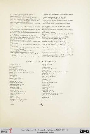
Abgebildete Gegenstände
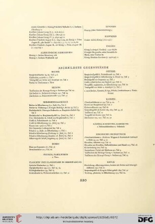
Abgebildete Gegenstände

Abgebildete Gegenstände

Bearbeiter: Deisenberger. Abgebildete Orte und Gegenstände: Luitpoldpark
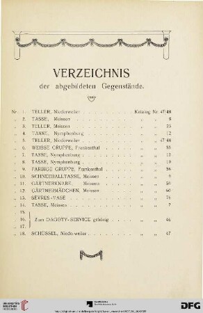
Verzeichnis der abgebildeten Gegenstände
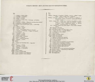
Verzeichniss der abgebildeten Gegenstände
München, Königliches Hoftheater. Abgebildete Orte und Gegenstände: Seitenansicht
München, Königliches Hoftheater. Situationsplan. Abgebildete Orte und Gegenstände: Grundriß
Windfang eines Amtsgebäudes. Abgebildete Orte und Gegenstände: Schwingtüre. Bemerkungen: Ansicht
Baulinienänderung an der Wredestraße. Abgebildete Orte und Gegenstände: Wredestraße, Massfeld
Münzenabbildungen. Abgewürdigte und Verrufene Münzen. Abgebildete Orte und Gegenstände: Münzen
Münzenabbildungen. Abgewürdigte und Verrufene Münzen. Abgebildete Orte und Gegenstände: Münzen
Abgebildete Gegenstände
Abgebildete Gegenstände
Abgebildete Gegenstände
Bearbeiter: Deisenberger. Abgebildete Orte und Gegenstände: Luitpoldpark
Verzeichnis der abgebildeten Gegenstände
Verzeichniss der abgebildeten Gegenstände
München, Königliches Hoftheater. Abgebildete Orte und Gegenstände: Seitenansicht
München, Königliches Hoftheater. Situationsplan. Abgebildete Orte und Gegenstände: Grundriß
Windfang eines Amtsgebäudes. Abgebildete Orte und Gegenstände: Schwingtüre. Bemerkungen: Ansicht
Baulinienänderung an der Wredestraße. Abgebildete Orte und Gegenstände: Wredestraße, Massfeld
Münzenabbildungen. Abgewürdigte und Verrufene Münzen. Abgebildete Orte und Gegenstände: Münzen