Karte / Plan
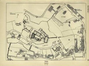
Waldshut: Lageplan des Rheins auf Gemarkung Waldshut, Maßstab: 1:1500
- Reference number
-
Abt. Staatsarchiv Freiburg, K 851/1 Nr. 578
- Former reference number
-
K 862/1 Nr. 0008
- Extent
-
1 Plan
- Dimensions
-
147 x 34 (Höhe x Breite)
- Context
-
Straßenbauämter >> Straßenbauamt Waldshut
- Holding
-
Landesarchiv Baden-Württemberg, Abt. Staatsarchiv Freiburg, K 851/1 Straßenbauämter
- Date of creation
-
1927
- Other object pages
- Rights
-
Es gelten die Nutzungsbedingungen des Landesarchivs Baden-Württemberg.
- Last update
- 17.04.2055, 2:09 AM CEST
Data provider
This object is provided by:
Landesarchiv Baden-Württemberg. If you have any questions about the object, please contact the data provider.
Landesarchiv Baden-Württemberg. If you have any questions about the object, please contact the data provider.
Object type
- Karten und Pläne
Time of origin
- 1927
Other Objects (12)

Waldshut: Lageplan des Rheins auf Gemarkung Waldshut, Maßstab: 1:1500
Waldshut: Lageplan des Rheins auf Gemarkung Waldshut, Maßstab: 1:1500
Heppenschwand: Lageplan, Maßstab: 1:1500
Dobelsäge, Roggenbach, Lageplan, Maßstab: 1:1500
Krunkelbachhütte Bernau, Lageplan, Maßstab: 1:1500
Lageplan 1:1500
Tiengen: Sonderabfalldeponie Tiengen, Lageplan, Maßstab: 1:1500
Staatsbrauerei, Kurhaus Rothaus, Lageplan, Maßstab: 1:1500
Staatsbrauerei, Kurhaus Rothaus, Lageplan, Maßstab: 1:1500
Lageplan der Wasserstation Waldshut
Schluchseewerk, 1. Teilausbau, Schluchseesperre, Lageplan, Maßstab: 1:1500
Stadt Waldshut, Waldshut
Waldshut: Lageplan des Rheins auf Gemarkung Waldshut, Maßstab: 1:1500
Waldshut: Lageplan des Rheins auf Gemarkung Waldshut, Maßstab: 1:1500
Heppenschwand: Lageplan, Maßstab: 1:1500
Dobelsäge, Roggenbach, Lageplan, Maßstab: 1:1500
Krunkelbachhütte Bernau, Lageplan, Maßstab: 1:1500
Lageplan 1:1500
Tiengen: Sonderabfalldeponie Tiengen, Lageplan, Maßstab: 1:1500
Staatsbrauerei, Kurhaus Rothaus, Lageplan, Maßstab: 1:1500
Staatsbrauerei, Kurhaus Rothaus, Lageplan, Maßstab: 1:1500
Lageplan der Wasserstation Waldshut
Schluchseewerk, 1. Teilausbau, Schluchseesperre, Lageplan, Maßstab: 1:1500