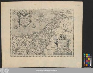
Grafik | Landkarte
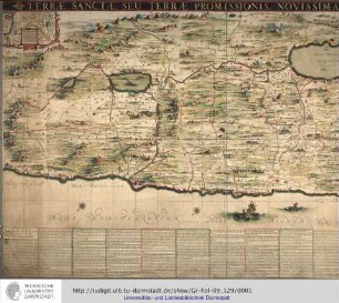
Novißima totius Terrae Sanctae sive promissionis
Historische Karte von Palästina und dem Mittelmeer mit Titelkartusche oben in der Mitte. Links oben Legende, rechts oben Maßstab. Unten mittig ein Stadtplan
- Alternative title
-
descriptio
- Collection
-
Pictothek
- Identifier
-
36/A 1.31
- Source
-
Universitätsbibliothek Würzburg
- Extent
-
555 mm x 465 mm
- Language
-
Latein
- Subject
-
Altkarte
- Subject (where)
-
Palästina
- Event
-
Geistige Schöpfung
- (who)
- (when)
-
Ca. 1710
- Event
-
Veröffentlichung
- (who)
-
Funck, David
- URN
-
urn:nbn:de:bvb:20-36a131term73588607-4
- Last update
-
06.03.2025, 3:26 PM CET
Data provider
This object is provided by:
Universitätsbibliothek Würzburg. If you have any questions about the object, please contact the data provider.
Universitätsbibliothek Würzburg. If you have any questions about the object, please contact the data provider.
Object type
- Grafik
- Landkarte
Associated
- Homann, Johann Baptist
- Funck, David
Time of origin
- Ca. 1710
Other Objects (12)

Novissima totius Terræ Sanctæ Sive Promissionis Descriptio
Terrae Sanctae, Seu Terrae Promissionis, Novissima Descriptio.

Novissima totius Terrae Sanctae Sive Promissionis Descriptio Edita per Davidem Funcken, Norimberga Karte Israels Zeichner: David Funcke
Novissima totius Terrae Sanctae Sive Promissionis Descriptio Edita per Davidem Funcken Norimbergae Karte Israels Zeichner: David Funcken (Laufzeit erschlossen)
Palaestinae sive totius Terrae Promissionis Nova Descriptio
Totius Terræ Sanctæ Delineatio
Nova, Ac Verissima Totius Terrae Sanctae Descriptio
Palaestinae Sive Totivs Terræ Promissionis Nova Descriptio

Loca Terrae Sanctae
Itinerarium terrae sanctae
Hic describitur visitatio Totius terrae sanctae, quam hujus temporis peregrinatores perlustrant.
De itinere terrae sanctae
Novissima totius Terræ Sanctæ Sive Promissionis Descriptio
Terrae Sanctae, Seu Terrae Promissionis, Novissima Descriptio.
Novissima totius Terrae Sanctae Sive Promissionis Descriptio Edita per Davidem Funcken, Norimberga Karte Israels Zeichner: David Funcke
Novissima totius Terrae Sanctae Sive Promissionis Descriptio Edita per Davidem Funcken Norimbergae Karte Israels Zeichner: David Funcken (Laufzeit erschlossen)
Palaestinae sive totius Terrae Promissionis Nova Descriptio
Totius Terræ Sanctæ Delineatio
Nova, Ac Verissima Totius Terrae Sanctae Descriptio
Palaestinae Sive Totivs Terræ Promissionis Nova Descriptio
Loca Terrae Sanctae
Itinerarium terrae sanctae
Hic describitur visitatio Totius terrae sanctae, quam hujus temporis peregrinatores perlustrant.