- Alternativer Titel
-
Velhagen und Klasings Karte von Europa
- Standort
-
Deutsches Historisches Museum, Berlin
- Inventarnummer
-
Do 70/626II
- Maße
-
Höhe x Breite: 69,4 x 81,4 cm
- Material/Technik
-
Papier, gedruckt
- Klassifikation
-
Kartografie (Gattung)
- Bezug (was)
-
Weltkrieg, 2.
- Ereignis
-
Herstellung
- (wer)
-
Verlag: Velhagen & Klasing
- (wo)
-
Leipzig Bielefeld, Deutschland [historisch: Deutsches Reich]
- (wann)
-
1940
- Rechteinformation
-
Deutsches Historisches Museum
- Letzte Aktualisierung
-
24.03.2023, 09:29 MEZ
Datenpartner
Dieses Objekt wird bereitgestellt von:
Stiftung Deutsches Historisches Museum. Bei Fragen zum Objekt wenden Sie sich bitte an den Datenpartner.
Stiftung Deutsches Historisches Museum. Bei Fragen zum Objekt wenden Sie sich bitte an den Datenpartner.
Objekttyp
- Politisch-administrative Karte
Beteiligte
- Verlag: Velhagen & Klasing
Entstanden
- 1940
Ähnliche Objekte (12)
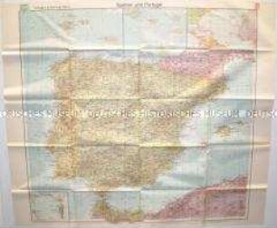
Politisch-geografische Karte von Spanien und Portugal

Politisch-geografische Karte des europäischen Teils der Sowjetunion
Die Völker Europas und der Erde : Völkerkarten von Mitteleuropa, Europa und der Erde ; Karten d. Verbreitung d. Deutschen, statist. Zeichnungen u. Zahlenangaben
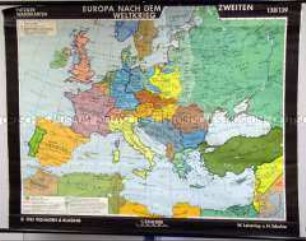
Schulwandkarte von Europa nach dem 2. Weltkrieg

Karte von Frankreich
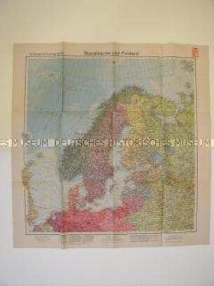
Geografische Karte von Nordeuropa
Geographisches Handbuch, Bd. 1.. Allgemeine Erdkunde, Länder- und Staatenkunde von Europa
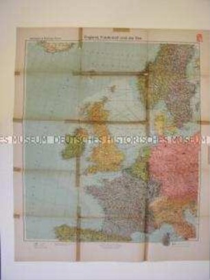
Geografische Karte von Großbritannien und Frankreich
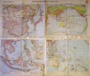
Karten der Kriegsschauplätze im Fernen Osten
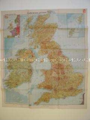
Wirtschafts-geografische Karte von Großbritannien und Irland
Karte des Deutschen Reiches und seiner Nachbarstaaten
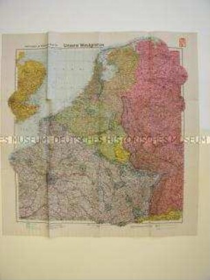
Geographische Karte von Westeuropa mit militärstrategischen Angaben
Politisch-geografische Karte von Spanien und Portugal
Politisch-geografische Karte des europäischen Teils der Sowjetunion
Die Völker Europas und der Erde : Völkerkarten von Mitteleuropa, Europa und der Erde ; Karten d. Verbreitung d. Deutschen, statist. Zeichnungen u. Zahlenangaben
Schulwandkarte von Europa nach dem 2. Weltkrieg
Karte von Frankreich
Geografische Karte von Nordeuropa
Geographisches Handbuch, Bd. 1.. Allgemeine Erdkunde, Länder- und Staatenkunde von Europa
Geografische Karte von Großbritannien und Frankreich
Karten der Kriegsschauplätze im Fernen Osten
Wirtschafts-geografische Karte von Großbritannien und Irland
Karte des Deutschen Reiches und seiner Nachbarstaaten