Regionalkarte
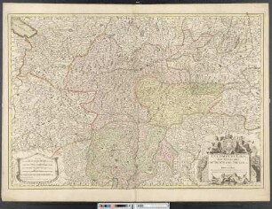
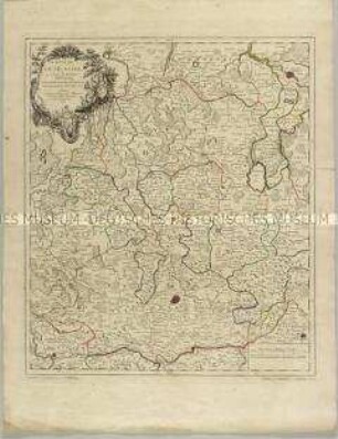
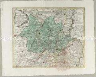
Grand Atlas . Bl. 68 (Bayern, Tirol, Augsburg, Allgäu...): Contenant une Partie de Baviére de Suabe du Comté de Tirol et de l'Eveché d'Augspourg, l'Algow, les quatres Seigneuries Autrichiennes devant la Montagne d'Arlenberg et et
- Alternative title
-
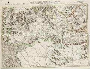
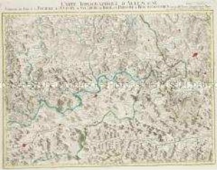
CARTE TOPOGRAPHIQUE D'ALLEMAGNE / Contenant une Partie de BAVIÉRE de SUABE du COMTÉ de TIROL et de l'EVECHÉ d'AUGSPOURG, l'ALGOW, les quatres SEIGNEURIES AUTRI- / CHIENNES devant la MONTAGNE d'ARLENBERG et et
- Location
-
Deutsches Historisches Museum, Berlin
- Inventory number
-
Do 2006/1059.68
- Measurements
-
Höhe x Breite: 56,5 x 78 cm, Höhe: 56,5 cm, Breite: 78 cm, Tiefe: 3 cm (Atlas)
Höhe x Breite: 56,5 x 78 cm (Blatt)
Höhe x Breite: 52 x 68 cm (Platte)
Höhe x Breite: 46 x 59 cm (Karte)
- Material/Technique
-
Papier, Kupferstich, koloriert, gebunden |Fadenheftung
- Classification
-
Kartografie (Gattung)
- Subject (what)
-
Deutschland
- Event
-
Herstellung
- (who)
-
Verleger, Militärkartograph: Johann Wilhelm Abraham Jaeger
Stecher: Johann Gottlieb Facius
- (where)
-
Frankfurt (Main) [historisch: Frankfurt, Reichsstadt], Deutschland
- (when)
-
um 1787
- Rights
-
Deutsches Historisches Museum
- Last update
-
24.03.2023, 9:29 AM CET
Data provider
This object is provided by:
Stiftung Deutsches Historisches Museum. If you have any questions about the object, please contact the data provider.
Stiftung Deutsches Historisches Museum. If you have any questions about the object, please contact the data provider.
Object type
- Regionalkarte
Associated
- Verleger, Militärkartograph: Johann Wilhelm Abraham Jaeger
- Stecher: Johann Gottlieb Facius
Time of origin
- um 1787
Other Objects (12)
Grand Atlas . Bl. 78 (Tirol, Kärnten, Brixen): Contenant une Partie du Comte de Tirol et du Duche de Carinthie Superieure et l'Eveche de Brixen

Bl. XLIX: Le Comté du Tirol l'Eveché de Trente et de Brixen avec les Routtes et Passages.
Grand Atlas . Bl. 69 (Bayern, Salzburg, Tirol) : Contenant une Partie de la Baviere de l'Eveché de Salzburg, de Tirol, et la Prevoté de Berchtolsgaden,
L'Eveche et l'Etat de Liege
L'Eveche et l'Etat de Liege
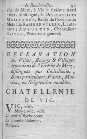
Déclaration des Villes, Bourgs et Villages dépendans de l'Évêché de Metz, distingués par Châtellenies, Bans particuliers, Vaulx, Mairies, ou Seigneuries notables.
Le Comté De Tirol, Les Eveschés De Trente et De Brixen, &c.
L'Eveché de Munster

Histoire de l'évêché de Bethléem
Monnaies de l'évéché de Sion
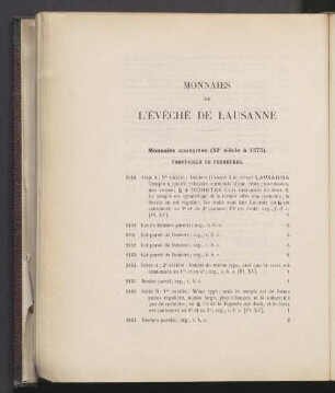
Monnaies de l'évéché de Lausanne
Carte de l'Evêché de Paderborn
Grand Atlas . Bl. 78 (Tirol, Kärnten, Brixen): Contenant une Partie du Comte de Tirol et du Duche de Carinthie Superieure et l'Eveche de Brixen
Bl. XLIX: Le Comté du Tirol l'Eveché de Trente et de Brixen avec les Routtes et Passages.
Grand Atlas . Bl. 69 (Bayern, Salzburg, Tirol) : Contenant une Partie de la Baviere de l'Eveché de Salzburg, de Tirol, et la Prevoté de Berchtolsgaden,
L'Eveche et l'Etat de Liege
L'Eveche et l'Etat de Liege
Déclaration des Villes, Bourgs et Villages dépendans de l'Évêché de Metz, distingués par Châtellenies, Bans particuliers, Vaulx, Mairies, ou Seigneuries notables.
Le Comté De Tirol, Les Eveschés De Trente et De Brixen, &c.
L'Eveché de Munster
Histoire de l'évêché de Bethléem
Monnaies de l'évéché de Sion
Monnaies de l'évéché de Lausanne