Karte / Plan
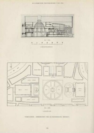
Gemeinde Hüls. Ausbau der Jerusalemstr. Lageplan, Längenschnitt. Blatt 1
- Reference number
-
3800
- Dimensions
-
720 x 360
- Further information
-
Standort: 22.17
Ausführung: Lichtpause
Maßstab: 1 : 500, 1 : 50
- Context
-
Karten und Pläne >> Überregionale Karten >> Siedlungen in NRW >> Krefeld >> Hüls
- Holding
-
S 2a Karten und Pläne Karten und Pläne
- Indexentry person
-
Dipl.-Ing. W. Jores, Bauing. BdB R. Mertens, Ingenieurbüro, Krefeld, Verfasser
- Indexentry place
-
Hüls
- Date of creation
-
1965
- Other object pages
- Provenance
-
Kr. Kempen-Krefeld Nr. 14552
- Delivered via
- Last update
-
15.07.2117, 7:21 AM CEST
Data provider
This object is provided by:
Kreisarchiv Viersen. If you have any questions about the object, please contact the data provider.
Kreisarchiv Viersen. If you have any questions about the object, please contact the data provider.
Object type
- Karten und Pläne
Time of origin
- 1965
Other Objects (12)

Schankkonzession: Hüls, Jerusalemstr. 9 (Otto Zill)
Längenschnitt ; Lageplan
Längenschnitt und Lageplan
Längenschnitt und Lageplan zum Ausbau der Helwigstraße, Stadtbauamt Lemgo (Düwel), Handzeichnung
Regenwasserkanal "Feldmühlenweg". Längenschnitt und Lageplan
Ausbau des Flakenfließes. Anl. 4 - Längenschnitt
Schleusenverzeichnis. Schleuse Liepe. Grundriss, Längenschnitt, Lageplan
Schleusenverzeichnis. Schleuse Hohensaathen. Grundriss, Längenschnitt, Lageplan
Entwurf zu Arbeiterwohnhäusern; Seitenansicht, Längenschnitt, Lageplan
Ausbau der Unterspree. Längenschnitt der bestehenden Industriebahn
Entwurf zu einem Arbeiterwohnhaus; Seitenansicht, Längenschnitt, Lageplan
Kirche in Drachhausen. Entwurfsskizze. Längenschnitt und Lageplan
Schankkonzession: Hüls, Jerusalemstr. 9 (Otto Zill)
Längenschnitt ; Lageplan
Längenschnitt und Lageplan
Längenschnitt und Lageplan zum Ausbau der Helwigstraße, Stadtbauamt Lemgo (Düwel), Handzeichnung
Regenwasserkanal "Feldmühlenweg". Längenschnitt und Lageplan
Ausbau des Flakenfließes. Anl. 4 - Längenschnitt
Schleusenverzeichnis. Schleuse Liepe. Grundriss, Längenschnitt, Lageplan
Schleusenverzeichnis. Schleuse Hohensaathen. Grundriss, Längenschnitt, Lageplan
Entwurf zu Arbeiterwohnhäusern; Seitenansicht, Längenschnitt, Lageplan
Ausbau der Unterspree. Längenschnitt der bestehenden Industriebahn
Entwurf zu einem Arbeiterwohnhaus; Seitenansicht, Längenschnitt, Lageplan