Karte / Plan
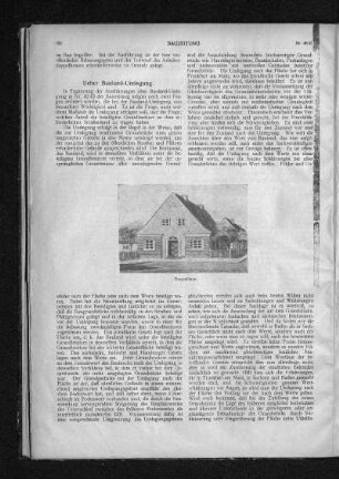
Ausgeführte Bauland- Umlegung an der Moltkestraße und Gneisenaustraße
- Reference number
-
5-1-0 Plankammer, 5-1-0-1109.0000
- Former reference number
-
F 29, M 46, Nr. 323
- Dimensions
-
648 x 1241
- Formal description
-
Plan oberer Teil: alter Bestand zwischen Münsterstraße, Blücherstraße und Prinz-Georg-Straße; unterer Teil neuer Bestand gleichen Gebietes.
- Material
-
Papier; auf Leinen
- Further information
-
Ausführung: Tuschzeichnung; Aquarell
Maßstab: 1:1.000
- Context
-
Plankammer >> Düsseldorf, gesamt >> Stadtplanung >> Umlegungen
- Holding
-
5-1-0 Plankammer Plankammer
- Date of creation
-
1912
- Other object pages
- Provenance
-
Stadtplanung
- Delivered via
- Last update
-
05.11.2025, 3:59 PM CET
Data provider
This object is provided by:
Stadtarchiv Düsseldorf. If you have any questions about the object, please contact the data provider.
Stadtarchiv Düsseldorf. If you have any questions about the object, please contact the data provider.
Object type
- Karten und Pläne
Time of origin
- 1912
Other Objects (12)

Feldstraße - Gneisenaustraße - Beselerallee - Forstweg - Esmarchstraße - Moltkestraße
Bauland-Umlegung
Bauland-Umlegung
Zwangsversteigerung Mahlower Straße, Moltkestraße, Gneisenaustraße 14a u. a. (Teltow)
Über Bauland-Umlegung
Über Bauland-Umlegung
Ortsstatut wegen Umlegung von Bauland
Gneisenaustraße
Gneisenaustraße
Gneisenaustraße
Gneisenaustraße
Gneisenaustraße
Feldstraße - Gneisenaustraße - Beselerallee - Forstweg - Esmarchstraße - Moltkestraße
Bauland-Umlegung
Bauland-Umlegung
Zwangsversteigerung Mahlower Straße, Moltkestraße, Gneisenaustraße 14a u. a. (Teltow)
Über Bauland-Umlegung
Über Bauland-Umlegung
Ortsstatut wegen Umlegung von Bauland
Gneisenaustraße
Gneisenaustraße
Gneisenaustraße
Gneisenaustraße