Seekarte | Topographische Karte
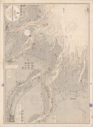
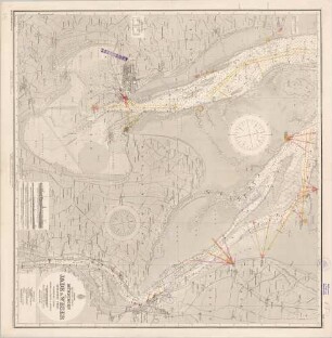
1875 Nordsee; North sea - Germany. Die Jade to Norder Piep including Helgoland and the entrances to Die Jade, Die Weser and Die Elbe
- Standort
-
Greifswald
- Sammlung
-
Kartensammlung des Instituts für Geographie und Geologie (Universität Greifswald)
- Inventarnummer
-
SE/Z14.06/GB1875
- Maße
-
Maßstab 1:100.000
- Material/Technik
-
Papier;
- Klassifikation
-
Kartographie
- Ereignis
-
Herstellung
- (wann)
-
1954 - 1973 jüngste Jahresangabe ist der Zeitpunkt der letzten Berichtigung
- Letzte Aktualisierung
-
25.03.2025, 09:46 MEZ
Datenpartner
Dieses Objekt wird bereitgestellt von:
Universität Greifswald. Kartensammlung des Instituts für Geographie und Geologie. Bei Fragen zum Objekt wenden Sie sich bitte an den Datenpartner.
Universität Greifswald. Kartensammlung des Instituts für Geographie und Geologie. Bei Fragen zum Objekt wenden Sie sich bitte an den Datenpartner.
Objekttyp
- Topographische Karte; Seekarte
Entstanden
- 1954 - 1973 jüngste Jahresangabe ist der Zeitpunkt der letzten Berichtigung
Ähnliche Objekte (12)

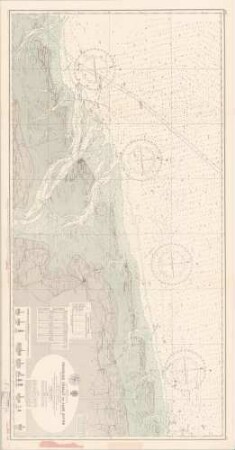
3767 Nordsee; Germany. Norder Piep to Vortrapp Teif including Helgoland
3767 Nordsee; North sea - Germany. Norder Piep to Vortrapp Tief including Helgoland
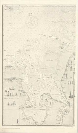
3761 Nordsee; East Frisian Islands. Friesche Zeegat to Jade River
3369 Nordsee; Germany. Die Jade
3368 Nordsee; North sea - Germany. Approaches to Die Jade and Die Waser
85a Nordsee; die Mündungen der Jade, Weser & Elbe
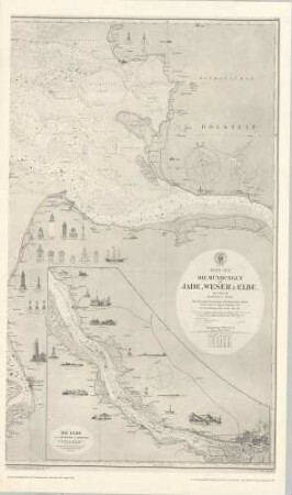
85a Nordsee; die Mündungen der Jade, Weser & Elbe
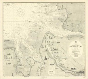
49 Nordsee; Die Mündungen, Jade, Weser und Elbe

49 Nordsee; deutsche Küste. Mündungen der Jade, Wesser & Elbe
2d Nordsee; deutsche Küste. Mündungen der Jade und Weser
49 Nordsee; deutsche Küste. Mündungen der Jade, Wesser & Elbe
56a Nordsee; deutsche Küste. Mündungen der Jade & Weser. Südlicher Theil
3767 Nordsee; Germany. Norder Piep to Vortrapp Teif including Helgoland
3767 Nordsee; North sea - Germany. Norder Piep to Vortrapp Tief including Helgoland
3761 Nordsee; East Frisian Islands. Friesche Zeegat to Jade River
3369 Nordsee; Germany. Die Jade
3368 Nordsee; North sea - Germany. Approaches to Die Jade and Die Waser
85a Nordsee; die Mündungen der Jade, Weser & Elbe
85a Nordsee; die Mündungen der Jade, Weser & Elbe
49 Nordsee; Die Mündungen, Jade, Weser und Elbe
49 Nordsee; deutsche Küste. Mündungen der Jade, Wesser & Elbe
2d Nordsee; deutsche Küste. Mündungen der Jade und Weser
49 Nordsee; deutsche Küste. Mündungen der Jade, Wesser & Elbe