Luftbildplan
Bous (Saar), Gauß-Krüger-Koordinaten: Rechtswert: 2558, Hochwert: 5460
- Archivalientitel
-
Bous West (Saar), Gauß-Krüger-Koordinaten: Rechtswert: 2556, Hochwert: 5460
- Maße
-
Maßstab: 1:10.000
- Sonstige Erschließungsangaben
-
Land: Saarland
- Kontext
-
Hansa Luftbild: Luftbildpläne 1:10.000 >> 2. Rechtswerte beginnend mit 25 >> Bous West (Saar), Gauß-Krüger-Koordinaten: Rechtswert: 2556, Hochwert: 5460
- Bestand
-
RW 0434 Hansa Luftbild: Luftbildpläne 1:10.000
- Urheber
-
Hersteller: Hansa Luftbild
- Laufzeit
-
1961
- Weitere Objektseiten
- Provenienz
-
Hansa Luftbild
- Geliefert über
- Letzte Aktualisierung
-
17.09.2025, 15:27 MESZ
Datenpartner
Dieses Objekt wird bereitgestellt von:
Landesarchiv Nordrhein-Westfalen. Abteilung Rheinland. Bei Fragen zum Objekt wenden Sie sich bitte an den Datenpartner.
Landesarchiv Nordrhein-Westfalen. Abteilung Rheinland. Bei Fragen zum Objekt wenden Sie sich bitte an den Datenpartner.
Objekttyp
- Luftbildpläne
Beteiligte
- Hersteller: Hansa Luftbild
Entstanden
- 1961
Ähnliche Objekte (12)

Bous (Saar), Gauß-Krüger-Koordinaten: Rechtswert: 2558, Hochwert: 5460

Bous (Saar), Gauß-Krüger-Koordinaten: Rechtswert: 2558, Hochwert: 5460

Bous Saar, Gauß-Krüger-Koordinaten: Rechtswert: 2558, Hochwert: 5460
Bous West Saar, Gauß-Krüger-Koordinaten: Rechtswert: 2556, Hochwert: 5460

Bous West (Saar), Gauß-Krüger-Koordinaten: Rechtswert: 2556, Hochwert: 5460

Bous West (Saar), Gauß-Krüger-Koordinaten: Rechtswert: 2556, Hochwert: 5460

Bous (Saar)-West, Gauß-Krüger-Koordinaten: Rechtswert: 2556, Hochwert: 5460
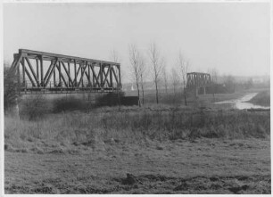
Eisenbahnbrücke Bous-Wadgassen/Saar
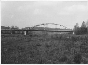
Straßenbrücke Bous-Wadgassen/Saar

Straßenbrücke Bous-Wadgassen/Saar

Eisenbahnbrücke Bous-Wadgassen/Saar
Derlen, Gauß-Krüger-Koordinaten: Rechtswert: 2560, Hochwert: 5460
Bous (Saar), Gauß-Krüger-Koordinaten: Rechtswert: 2558, Hochwert: 5460
Bous (Saar), Gauß-Krüger-Koordinaten: Rechtswert: 2558, Hochwert: 5460
Bous Saar, Gauß-Krüger-Koordinaten: Rechtswert: 2558, Hochwert: 5460
Bous West Saar, Gauß-Krüger-Koordinaten: Rechtswert: 2556, Hochwert: 5460
Bous West (Saar), Gauß-Krüger-Koordinaten: Rechtswert: 2556, Hochwert: 5460
Bous West (Saar), Gauß-Krüger-Koordinaten: Rechtswert: 2556, Hochwert: 5460
Bous (Saar)-West, Gauß-Krüger-Koordinaten: Rechtswert: 2556, Hochwert: 5460
Eisenbahnbrücke Bous-Wadgassen/Saar
Straßenbrücke Bous-Wadgassen/Saar
Straßenbrücke Bous-Wadgassen/Saar
Eisenbahnbrücke Bous-Wadgassen/Saar