- Reference number
-
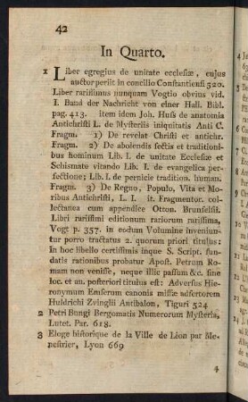
156
- Dimensions
-
275 x 350
- Notes
-
Pap., auf Lw, Or.: N, Begrenzung: Poulheim-Neuheim-Gey-Wenau-Münz
- Further information
-
Standort: 13.04
Ausführung: Dreifarbig
Maßstab: 1 : 100.000
Druck / Verlag: Hauptvertrieb der Karten der kgl. LA, R. Eisenschmidt, Berlin NW, Dorotheenstr. 70 a, Im Deutschen Offiziersverein
- Context
-
Karten und Pläne >> Überregionale Karten >> Topographische Karten
- Holding
-
S 2a Karten und Pläne Karten und Pläne
- Indexentry person
-
Kgl. LA, Herausgeber
- Indexentry place
-
Düren
- Date of creation
-
1895
- Other object pages
- Delivered via
- Last update
-
05.11.2025, 4:15 PM CET
Data provider
This object is provided by:
Kreisarchiv Viersen. If you have any questions about the object, please contact the data provider.
Kreisarchiv Viersen. If you have any questions about the object, please contact the data provider.
Object type
- Karten und Pläne
Time of origin
- 1895
Other Objects (12)

Topografische Karte des Kreises Düren
4269
42-69

Nr. 4269
Blatt 4269 Kobylin
Bankbelege (4022-4269)
Blatt 4269 Kobylin
Blatt 4269 Kobylin

Kniegrotte 32.69-42.69
CIL XV 4269, Schede

cn coin 4269 (Maroneia)
RGW-Thema 42/69
Topografische Karte des Kreises Düren
4269
42-69
Nr. 4269
Blatt 4269 Kobylin
Bankbelege (4022-4269)
Blatt 4269 Kobylin
Blatt 4269 Kobylin
Kniegrotte 32.69-42.69
CIL XV 4269, Schede
cn coin 4269 (Maroneia)
RGW-Thema 42/69
Topografische Karte des Kreises Düren
4269
42-69
Nr. 4269
Blatt 4269 Kobylin
Bankbelege (4022-4269)
Blatt 4269 Kobylin
Blatt 4269 Kobylin
Kniegrotte 32.69-42.69
CIL XV 4269, Schede
cn coin 4269 (Maroneia)