Karte / Plan
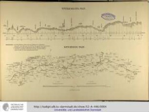
Lippe: Situationsplan eines Theiles der Lippe bei Hamm nebst Nivellements- und Querprofilen
- Former reference number
-
Lippe-Verband (Dep.); Wasserstraßenamt Hamm, Plankammer Lippe, Abt. Ib, Nr. 13, Schrank 7, Fach 2
- Dimensions
-
Höhe: 48 cm, Breite: 68 cm, Maßstab: in Fuß und Ruthen
- Further information
-
Ort: Lippe
- Context
-
Karten A (Allgemein) >> 3. Gewässer >> 3.1. Gewässer / Wasserbau >> 3.1.3. Lippe
- Holding
-
W 051 Karten A (Allgemein)
- Indexentry place
-
Lippe
- Date of creation
-
1848
- Other object pages
- Provenance
-
Sammlungsregistraturbildner
- Delivered via
- Last update
-
05.11.2025, 3:29 PM CET
Data provider
This object is provided by:
Landesarchiv Nordrhein-Westfalen. Abteilung Westfalen. If you have any questions about the object, please contact the data provider.
Landesarchiv Nordrhein-Westfalen. Abteilung Westfalen. If you have any questions about the object, please contact the data provider.
Object type
- Karten / Pläne
Time of origin
- 1848
Other Objects (12)

Lippe: Nivellements und Situations-Plan des Lippe-Flusses von km 84,8 bis km 95,6
Nivellements-Plan / Situations-Plan

Situationsplan zu den Querprofilen des Rheinufers am Düsseldorfer Werfte

Lippe: Situationsplan der Lippe bei Heeßen

Lippe: Nivellements-Profil der Lippe von Lippstadt bis Dahl (2. Blatt)
Bahnhof Schkölen. Nivellements- und Situationsplan
Haltepunkt Waldau. Nivellements- und Situationsplan
Haltestelle Cauerwitz. Nivellements- und Situationsplan
Bahnhof Osterfeld. Nivellements- und Situationsplan
Zweigleisige Eisenbahnbrücke: Nivellements- und Situationsplan
Nivellements- und Situationsplan. Wasserletiung Hasselfelde
Forst Zinna: Die vier Torfbrücher in der Liebätzer Heide; Situationsplan mit Querprofilen
Lippe: Nivellements und Situations-Plan des Lippe-Flusses von km 84,8 bis km 95,6
Nivellements-Plan / Situations-Plan
Situationsplan zu den Querprofilen des Rheinufers am Düsseldorfer Werfte
Lippe: Situationsplan der Lippe bei Heeßen
Lippe: Nivellements-Profil der Lippe von Lippstadt bis Dahl (2. Blatt)
Bahnhof Schkölen. Nivellements- und Situationsplan
Haltepunkt Waldau. Nivellements- und Situationsplan
Haltestelle Cauerwitz. Nivellements- und Situationsplan
Bahnhof Osterfeld. Nivellements- und Situationsplan
Zweigleisige Eisenbahnbrücke: Nivellements- und Situationsplan
Nivellements- und Situationsplan. Wasserletiung Hasselfelde