- Reference number
-
480
- Further information
-
Standort: 31.06
Maßstab: 1:2.000.000
- Context
-
Karten und Pläne Stadt Viersen >> 9. Kriegskarten
- Holding
-
S 2c Karten und Pläne Stadt Viersen Karten und Pläne Stadt Viersen
- Indexentry place
-
Westwall
Maginot-Linie
Weltkrieg II.
- Other object pages
- Delivered via
- Last update
-
05.11.2025, 3:14 PM CET
Data provider
This object is provided by:
Kreisarchiv Viersen. If you have any questions about the object, please contact the data provider.
Kreisarchiv Viersen. If you have any questions about the object, please contact the data provider.
Object type
- Karten und Pläne
Other Objects (12)

Westwall und Maginot-Linie

Kriegskarte von Westeuropa mit Westwall und Maginot-Linie
Die Maginot-Linie
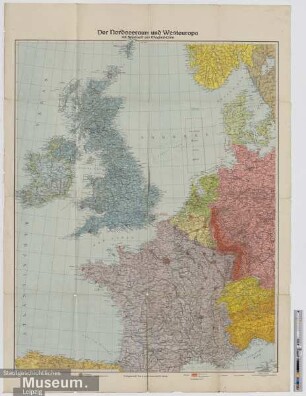
Der Nordseeraum und Westeuropa mit Westwall und Maginot-Linie
Kriegs-Karte von Westeuropa mit Westwall und Maginot-Linie
Westwall, Maginot-Linie, Atlantikwall : Bunker- u. Festungsbau 1930 - 1945
Westwall, Maginot-Linie, Atlantikwall : Bunker- u. Festungsbau 1930 - 1945
Hinter der Maginot-Linie
Karte Westfeldzug (Maginot-Linie)
Maginot-Linie an Frankreichs Westgrenze
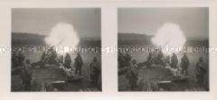
Zerstörungsfeuer gegen die Maginot-Linie
Bildbenutzung Peter Mühlschlegel. - Maginot-Linie
Westwall und Maginot-Linie
Kriegskarte von Westeuropa mit Westwall und Maginot-Linie
Die Maginot-Linie
Der Nordseeraum und Westeuropa mit Westwall und Maginot-Linie
Kriegs-Karte von Westeuropa mit Westwall und Maginot-Linie
Westwall, Maginot-Linie, Atlantikwall : Bunker- u. Festungsbau 1930 - 1945
Westwall, Maginot-Linie, Atlantikwall : Bunker- u. Festungsbau 1930 - 1945
Hinter der Maginot-Linie
Karte Westfeldzug (Maginot-Linie)
Maginot-Linie an Frankreichs Westgrenze
Zerstörungsfeuer gegen die Maginot-Linie