Dortmund, Bundestagswahl, Wahlkreise, Stadtplan
Darin: Kartengrundlage: Amtliche Stadtkarte Dortmund 1 : 20 000 ; Stadtplanwerk Ruhrgebiet, Stand 1994/95
Enthält: mit Einzeichnungen der Wahlkreisgrenzen (zugleich Stadtbezirksgrenzen) und der Stadtbezirksgrenzen zur Bundestagswahl 1994
- Archivaliensignatur
-
200/01, 00/290
- Alt-/Vorsignatur
-
Registratursignatur: 2.3.2, 113
- Formalbeschreibung
-
Mittige Knickfalten
- Sonstige Erschließungsangaben
-
Maßstab: M. 1 : 20 000
- Kontext
-
Allgemeine Kartensammlung: Drucke und Reproduktionen (Einzelkarten) >> 02 THEMENKARTEN >> 02.03 Verwaltung und Statistik >> 02.03.02 Wahlen
- Bestand
-
200/01 Allgemeine Kartensammlung: Drucke und Reproduktionen (Einzelkarten)
- Urheber
-
Autor: hrsg. v. Stadt Dortmund, Amt für Statistik und Wahlen - StA 12;
Kartographie und Druck: Stadt Dortmund, Vermessungs- und Katasteramt
- Laufzeit
-
1994 - 1995
- Weitere Objektseiten
- Geliefert über
- Letzte Aktualisierung
-
17.09.2025, 15:36 MESZ
Datenpartner
Dieses Objekt wird bereitgestellt von:
Stadtarchiv Dortmund. Bei Fragen zum Objekt wenden Sie sich bitte an den Datenpartner.
Stadtarchiv Dortmund. Bei Fragen zum Objekt wenden Sie sich bitte an den Datenpartner.
Objekttyp
- Sonstiges
Beteiligte
- Autor: hrsg. v. Stadt Dortmund, Amt für Statistik und Wahlen - StA 12;<br />Kartographie und Druck: Stadt Dortmund, Vermessungs- und Katasteramt
Entstanden
- 1994 - 1995
Ähnliche Objekte (12)

Dortmund, Bundestagswahl, Wahlkreise, Stadtplan
Dortmund, Bundestagswahl, Wahlkreise, Stadtplan
Dortmund, Bundestagswahl, Wahlkreise, Stadtplan
Dortmund, Bundestagswahl, Wahlkreise, Stadtplan
Dortmund, Bundestagswahl, Wahlkreise, Übersichtskarte
Dortmund, Landtagswahl, Wahlkreise, Stadtplan
Dortmund, Landtagswahl, Wahlkreise, Stadtplan
Dortmund, Landtagswahl, Wahlkreise, Stadtplan
Einteilung der Wahlkreise zur Bundestagswahl in Dortmund
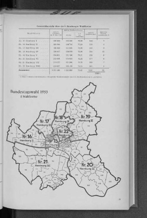
Bundestagswahl 1953: 8 Wahlkreise
Bundestagswahl 1953 (Wahlkreise), Band 1
Bundestagswahl 1953 (Wahlkreise), Band 3
Dortmund, Bundestagswahl, Wahlkreise, Stadtplan
Dortmund, Bundestagswahl, Wahlkreise, Stadtplan
Dortmund, Bundestagswahl, Wahlkreise, Stadtplan
Dortmund, Bundestagswahl, Wahlkreise, Stadtplan
Dortmund, Bundestagswahl, Wahlkreise, Übersichtskarte
Dortmund, Landtagswahl, Wahlkreise, Stadtplan
Dortmund, Landtagswahl, Wahlkreise, Stadtplan
Dortmund, Landtagswahl, Wahlkreise, Stadtplan
Einteilung der Wahlkreise zur Bundestagswahl in Dortmund
Bundestagswahl 1953: 8 Wahlkreise
Bundestagswahl 1953 (Wahlkreise), Band 1