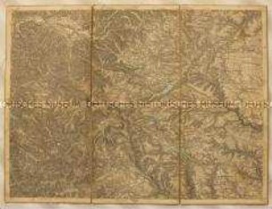
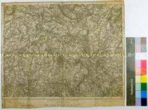
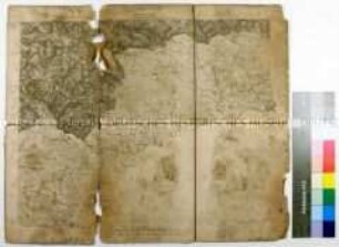
Militärkarte
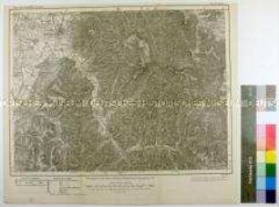
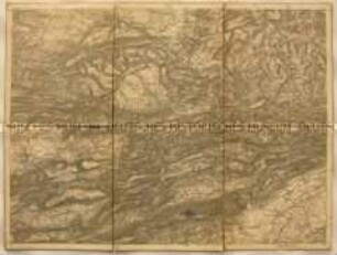
Topographische Karte der Gegend südöstlich von Hof zwischen Tanna, Lauterbach, Markneukirchen und Rehau
- Alternativer Titel
-
Karte des Deutschen Reiches. / 492. Hof.
- Standort
-
Deutsches Historisches Museum, Berlin
- Inventarnummer
-
Do 82/187
- Maße
-
Höhe x Breite: 29,6 x 36,2 cm (Blatt)
- Material/Technik
-
Druckfarbe (mehrfarbig), Papier, gedruckt
- Klassifikation
-
Landkarten (Gattung)
- Bezug (was)
-
Militär
Landschaft
Infrastruktur
- Ereignis
-
Herstellung
- (wo)
-
Deutschland [historisch: Deutsches Reich]
- (wann)
-
um 1900
- Rechteinformation
-
Deutsches Historisches Museum
- Letzte Aktualisierung
-
24.03.2023, 09:31 MEZ
Datenpartner
Dieses Objekt wird bereitgestellt von:
Stiftung Deutsches Historisches Museum. Bei Fragen zum Objekt wenden Sie sich bitte an den Datenpartner.
Stiftung Deutsches Historisches Museum. Bei Fragen zum Objekt wenden Sie sich bitte an den Datenpartner.
Objekttyp
- Militärkarte
Entstanden
- um 1900
Ähnliche Objekte (12)
Topographische Karte der Gegend südöstlich von Freiburg im Großherzogtum Baden zwischen Hammereisenbach, Grafenhausen und Schönau
Topographische Karte der Gegend südöstlich von Zwickau zwischen Werdau, Stollberg, Schwarzenberg und Auerbach im Königreich Sachsen
Topographische Karte der Gegend südöstlich von Sayda zwischen Teplitz, Katharinenberg und Görkau als Grenzgebiet zum Königreich Böhmen
Topographische Karte der Gegend südöstlich von Spantekow in Vorpommern mit verschiedenen Forsten zwischen Alt-Teterin, Putzar und Bresewitz
Topographische Karte der Gegend südöstlich von Offenburg zwischen Kniebis, Wolfach, Wallburg und Lahr im Königreich Württemberg und Großherzogtum Baden
Topographische Karte der Gegend südöstlich von Mamonowo (Heiligenbeil) zwischen Zinten, Guttenfeld, Plasswich und Braniewo (Braunsberg) im Königreich Preußen, Regierungsbezirk Königsberg
Topographische Karte der Gegend südöstlich von Simmern zwischen Stromberg, Sobernheim und Kirn im Königreich Preußen, dem Königreich Bayern und dem Großherzogtum Oldenburg

Topographische Karte der Gegend südöstlich von Mulhouse im Elsass mit der Rheinschleife zwischen Klein Landau, Basel und Rheinfelden als Reichsland Elsass-Lothringen und Großherzogtum Baden
Topographische Karte der Gegend südöstlich von Oltingen zwischen Delemont, Moutier, Wiedlisbach, Liestal, Laufen und Sondersdorf als Bezirk Oberelsass des Reichslandes Elsass-Lothringen, heute in der Schweiz
Topographische Karte der Gegend südöstlich von Oltingen zwischen Delemont, Moutier, Wiedlisbach, Liestal, Laufen und Sondersdorf als Bezirk Oberelsass des Reichslandes Elsass-Lothringen, heute in der Schweiz
Topographische Teilkarte der Gegend südöstlich vor Paris mit den französischen (rot) Befestigungsanlagen vor Charenton und Vincennes sowie der Marneschleife mit Chennevière und Marolles während des Deutsch-Französischen Krieges
Topographische Teilkarte der Gegend nordöstlich vor Paris mit den französischen (rot) Befestigungsanlagen bei Noisy, Stains, Villepinte und Neuilly während des Deutsch-Französischen Krieges
Topographische Karte der Gegend südöstlich von Freiburg im Großherzogtum Baden zwischen Hammereisenbach, Grafenhausen und Schönau
Topographische Karte der Gegend südöstlich von Zwickau zwischen Werdau, Stollberg, Schwarzenberg und Auerbach im Königreich Sachsen
Topographische Karte der Gegend südöstlich von Sayda zwischen Teplitz, Katharinenberg und Görkau als Grenzgebiet zum Königreich Böhmen
Topographische Karte der Gegend südöstlich von Spantekow in Vorpommern mit verschiedenen Forsten zwischen Alt-Teterin, Putzar und Bresewitz
Topographische Karte der Gegend südöstlich von Offenburg zwischen Kniebis, Wolfach, Wallburg und Lahr im Königreich Württemberg und Großherzogtum Baden
Topographische Karte der Gegend südöstlich von Mamonowo (Heiligenbeil) zwischen Zinten, Guttenfeld, Plasswich und Braniewo (Braunsberg) im Königreich Preußen, Regierungsbezirk Königsberg
Topographische Karte der Gegend südöstlich von Simmern zwischen Stromberg, Sobernheim und Kirn im Königreich Preußen, dem Königreich Bayern und dem Großherzogtum Oldenburg
Topographische Karte der Gegend südöstlich von Mulhouse im Elsass mit der Rheinschleife zwischen Klein Landau, Basel und Rheinfelden als Reichsland Elsass-Lothringen und Großherzogtum Baden
Topographische Karte der Gegend südöstlich von Oltingen zwischen Delemont, Moutier, Wiedlisbach, Liestal, Laufen und Sondersdorf als Bezirk Oberelsass des Reichslandes Elsass-Lothringen, heute in der Schweiz
Topographische Karte der Gegend südöstlich von Oltingen zwischen Delemont, Moutier, Wiedlisbach, Liestal, Laufen und Sondersdorf als Bezirk Oberelsass des Reichslandes Elsass-Lothringen, heute in der Schweiz
Topographische Teilkarte der Gegend südöstlich vor Paris mit den französischen (rot) Befestigungsanlagen vor Charenton und Vincennes sowie der Marneschleife mit Chennevière und Marolles während des Deutsch-Französischen Krieges