- Alternative title
-
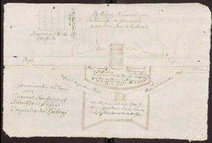
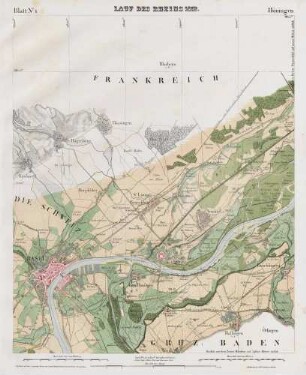
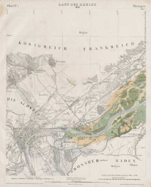
PLAN / Der Festung / HÜNINGEN / nebst Charte
- Location
-
Deutsches Historisches Museum, Berlin
- Inventory number
-
Do 2006/378
- Measurements
-
Höhe x Breite: 48 x 38 cm (Blatt)
Höhe x Breite: 14,8 x 24,4 cm (Karte)
Höhe x Breite: 29,4 x 26,5 cm (Platte)
- Material/Technique
-
Druckfarbe, Papier, Kupferstich, koloriert
- Classification
-
Kartografie (Gattung)
- Subject (what)
-
Hüningen
Basel
- Event
-
Herstellung
- (who)
-
Verleger ?: J. B. Klein
Stecher: K. F. Müller (jun.)
- (where)
-
Leipzig [historisch: Leipzig], Deutschland [historisch: Heiliges Römisches Reich deutscher Nation]
- (when)
-
1793
- Rights
-
Deutsches Historisches Museum
- Last update
-
24.03.2023, 9:27 AM CET
Data provider
This object is provided by:
Stiftung Deutsches Historisches Museum. If you have any questions about the object, please contact the data provider.
Stiftung Deutsches Historisches Museum. If you have any questions about the object, please contact the data provider.
Object type
- Fortifikationsplan
Associated
- Verleger ?: J. B. Klein
- Stecher: K. F. Müller (jun.)
Time of origin
- 1793
Other Objects (12)

Pläne der Festungen Hüningen und Kehl
Hüningen: Festung, Planskizze
Zerstörung der Festung Hüningen; Anlegung einer Schiffbrücke bei Hüningen; Brückengeldbestimmung
Holzkontributionslieferung an die französische Festung Hüningen
"Le plan de Hüningen"
Umgebungskarte von Stadt und Festung Mainz
Hüningen

Hüningen
Hüningen

Hüningen
Hüningen
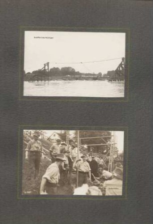
oben: "Schiffsbrücke Hüningen" unten: "Hüningen - Zollrevision"
Pläne der Festungen Hüningen und Kehl
Hüningen: Festung, Planskizze
Zerstörung der Festung Hüningen; Anlegung einer Schiffbrücke bei Hüningen; Brückengeldbestimmung
Holzkontributionslieferung an die französische Festung Hüningen
"Le plan de Hüningen"
Umgebungskarte von Stadt und Festung Mainz
Hüningen
Hüningen
Hüningen
Hüningen
Hüningen