Karte / Plan
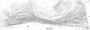
K 9 Ortslage Amern-Linde von km 4+898 bis km 5+008. K 5 von km 0+000 bis km 0+448,40 (Lageplan)
- Reference number
-
3374
- Dimensions
-
930 x 290
- Further information
-
Standort: 22.09
Ausführung: Lichtpause, teilkoloriert
Maßstab: 1 : 1000
- Context
-
Karten und Pläne >> Bausachen >> Straßen
- Holding
-
S 2a Karten und Pläne Karten und Pläne
- Indexentry person
-
Ingenieurbau-Abt., Verfasser
- Indexentry place
-
Amern
- Date of creation
-
1964
- Other object pages
- Provenance
-
Kr. Kempen-Krefeld Nr. 13740 Bl. 7
- Delivered via
- Last update
-
05.11.2025, 4:07 PM CET
Data provider
This object is provided by:
Kreisarchiv Viersen. If you have any questions about the object, please contact the data provider.
Kreisarchiv Viersen. If you have any questions about the object, please contact the data provider.
Object type
- Karten und Pläne
Time of origin
- 1964
Other Objects (12)

K 9 Ortslage Amern - Linde von km 4+898 bis km 5+008, K 5 von km 0+000 bis km 0+448,40, Lageplan. Höhenplan K 5. K 5 Ortslage Amern - Linde, Regelquerschnitt
Bundesstraße Nr. 30, Ulm-Friedrichshafen, Umgehung Waldsee, km 0.000 - km 7.493 (Ostlinie, km 0.000 - km 5.660 (Westlinie)
Instandsetzung des kriegszerstörten Zollhausweges in Wittenweier km 0,000 - 0,750 und km 0,000 - km 0,200
Rheinbrücke Speyer rechtsrheinische Brückenrampe km 0+000 km 1+692
Strecke Halle-Cottbus: km 172,008, km 173,135, km 171,540
Bundesstraße Nr. 33, Umgehung Wollmatingen km 0,000 - km 5,583
Ausbau zwischen Aschhausen und Erlenbach km 0,000 - km 1,541
Neubau der Gemeindestraße Heppenschwand-Strittberg, km 0,000 - km 3,755
Ausbau der Maintalstraße bei Freudenberg, km 0,000 - km 1,500
Umgehung Rötenbach-Löffingen, km 41,600 - km 49,324 und 0,000 - km 7,427
Stuttgart Hbf: km 0+000 - 1+300
Verpachtung von Grundeigentum an der Straße Nr. 100 Heslach - Solitude, Markung Stuttgart, von km 0,000 bis km 3,332 und von km 0,000 bis km 7,684
K 9 Ortslage Amern - Linde von km 4+898 bis km 5+008, K 5 von km 0+000 bis km 0+448,40, Lageplan. Höhenplan K 5. K 5 Ortslage Amern - Linde, Regelquerschnitt
Bundesstraße Nr. 30, Ulm-Friedrichshafen, Umgehung Waldsee, km 0.000 - km 7.493 (Ostlinie, km 0.000 - km 5.660 (Westlinie)
Instandsetzung des kriegszerstörten Zollhausweges in Wittenweier km 0,000 - 0,750 und km 0,000 - km 0,200
Rheinbrücke Speyer rechtsrheinische Brückenrampe km 0+000 km 1+692
Strecke Halle-Cottbus: km 172,008, km 173,135, km 171,540
Bundesstraße Nr. 33, Umgehung Wollmatingen km 0,000 - km 5,583
Ausbau zwischen Aschhausen und Erlenbach km 0,000 - km 1,541
Neubau der Gemeindestraße Heppenschwand-Strittberg, km 0,000 - km 3,755
Ausbau der Maintalstraße bei Freudenberg, km 0,000 - km 1,500
Umgehung Rötenbach-Löffingen, km 41,600 - km 49,324 und 0,000 - km 7,427
Stuttgart Hbf: km 0+000 - 1+300