- Location
-
München, Bayerische Staatsbibliothek -- 2 Mapp. 212 o
- Dimensions
-
39 x 29 cm
- Extent
-
1 Kt.
- Language
-
Deutsch
- Notes
-
Lithographie
Maßstab in graph. Form (deutsche Meilen, preuss. Meilen). - Mit Bergstrichen
- Bibliographic citation
-
Sohr, Carl: Vollständiger Hand-Atlas der neueren Erdbeschreibung über alle Theile der Erde ; 28
- Series
-
Sohr, Carl: Vollständiger Hand-Atlas der neueren Erdbeschreibung über alle Theile der Erde; 28
- Keyword
-
Westfalen
- Event
-
Veröffentlichung
- (where)
-
Glogau
- (who)
-
C. Flemming
- (when)
-
[1848]
- Contributor
- URN
-
urn:nbn:de:bvb:12-bsb00042551-1
- Last update
- 27.11.2025, 8:48 AM CET
Data provider
This object is provided by:
Bayerische Staatsbibliothek. If you have any questions about the object, please contact the data provider.
Bayerische Staatsbibliothek. If you have any questions about the object, please contact the data provider.
Object type
- Altkarte
Associated
- Flemming, Carl (Sonstige)
- C. Flemming
Time of origin
- [1848]
Other Objects (12)

Die Fürstenthümer Lippe-Detmold, Schaunburg-Lippe und Waldeck

Die Fürstenthümer Lippe-Detmold und Schauenburg-Lippe

Koenigreich Hanover, Grossherzogthum Oldenburg, Herzogthum Braunschweig, die Fürstenthümer Lippe-Detmold, Schauenburg-Lippe und Waldeck und die Gebiete der freien Städte Hamburg, Lübeck und Bremen

Chorographische Karte des Königreichs Hannover, Grossherzogtums Oldenburg, Herzogthums Braunschweig, der Fürstenthümer Lippe-Detmold, Schaumburg Lippe und Pyrmont, der Gebiete der freien Reichsstädte Hamburg und Bremen und der angrenzenden Gegenden

Lippe

Lippe-Detmold; Schaumburg-Lippe
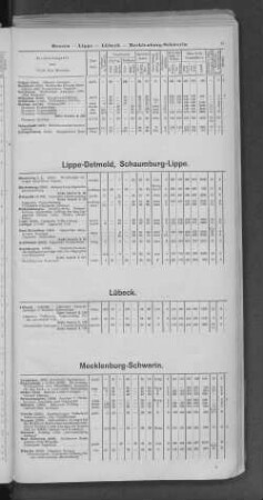
Lippe-Detmold, Schaumburg-Lippe.

Lippe-Detmold; Schaumburg-Lippe

Lippe : = Lippia

Die Grafschaft Lippe

Die Grafschaft Lippe
Koenigreich Hannover, Grossherzogthum Oldenburg, Herzogthum Braunschweig, die Fürstenthümer Lippe-Detmold, Schauenburg-Lippe und Waldeck und die Gebiete der freien Städte Hamburg, Lübeck und Bremen
Die Fürstenthümer Lippe-Detmold, Schaunburg-Lippe und Waldeck
Die Fürstenthümer Lippe-Detmold und Schauenburg-Lippe
Koenigreich Hanover, Grossherzogthum Oldenburg, Herzogthum Braunschweig, die Fürstenthümer Lippe-Detmold, Schauenburg-Lippe und Waldeck und die Gebiete der freien Städte Hamburg, Lübeck und Bremen
Chorographische Karte des Königreichs Hannover, Grossherzogtums Oldenburg, Herzogthums Braunschweig, der Fürstenthümer Lippe-Detmold, Schaumburg Lippe und Pyrmont, der Gebiete der freien Reichsstädte Hamburg und Bremen und der angrenzenden Gegenden
Lippe
Lippe-Detmold; Schaumburg-Lippe
Lippe-Detmold, Schaumburg-Lippe.
Lippe-Detmold; Schaumburg-Lippe
Lippe : = Lippia
Die Grafschaft Lippe
Die Grafschaft Lippe