- Alternative title
-
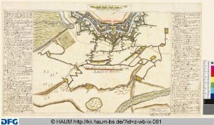
PLAN von LANDAU / und der dortigen Gegend, nebst der / jezigen Stellung und verschanzten / Lagern der Combinirten H. H. Armeen
- Location
-
Deutsches Historisches Museum, Berlin
- Inventory number
-
Do 2006/740
- Measurements
-
Höhe x Breite: 46,5 x 61 cm (Blatt)
Höhe x Breite: 33,5 x 45,7 cm (Karte)
Höhe x Breite: 37,5 x 49,5 cm (Platte)
- Material/Technique
-
Papier, Kupferstich?, koloriert
- Classification
-
Kartografie (Gattung)
- Subject (what)
-
Deutschland
- Event
-
Herstellung
- (who)
-
Kartograf: Frederick J. Bossler
- (where)
-
Deutschland
- (when)
-
um 1793
- Rights
-
Deutsches Historisches Museum
- Last update
- 24.03.2023, 9:29 AM CET
Data provider
This object is provided by:
Stiftung Deutsches Historisches Museum. If you have any questions about the object, please contact the data provider.
Stiftung Deutsches Historisches Museum. If you have any questions about the object, please contact the data provider.
Object type
- Belagerungskarte
Associated
- Kartograf: Frederick J. Bossler
Time of origin
- um 1793
Other Objects (12)

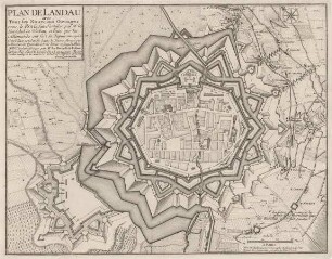
Plan von Landau

Plan de Landau

Plan de Landau

Plan de Landau

Plan de Landau

Plan de Landau

Plan und Panorama von Landau
Plan der Festung Landau
Plan der Festung Landau
Plan von Landau bei der Eroberung 1713
Plan von Landau mit der umliegenden Gegend
Postamt Landau, KFZ-Betriebsfahrstelle (17 Pläne)
Plan von Landau
Plan de Landau
Plan de Landau
Plan de Landau
Plan de Landau
Plan de Landau
Plan und Panorama von Landau
Plan der Festung Landau
Plan der Festung Landau
Plan von Landau bei der Eroberung 1713
Plan von Landau mit der umliegenden Gegend
Postamt Landau, KFZ-Betriebsfahrstelle (17 Pläne)
Plan von Landau
Plan de Landau
Plan de Landau
Plan de Landau
Plan de Landau
Plan de Landau
Plan und Panorama von Landau
Plan der Festung Landau
Plan der Festung Landau
Plan von Landau bei der Eroberung 1713
Plan von Landau mit der umliegenden Gegend