- Alternative title
-
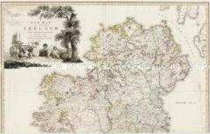
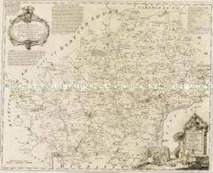
A / New Map / OF IRELAND / having the Great Features of the Country
- Location
-
Deutsches Historisches Museum, Berlin
- Inventory number
-
Do 2006/284
- Measurements
-
Höhe x Breite: 100,5 x 67,5 cm (Blatt)
Höhe x Breite: 70 x 57,5 cm (Karte)
Höhe x Breite: 73,8 x 62 cm (Platte)
- Material/Technique
-
Druckfarbe, Papier, Kupferstich, grenzkoloriert
- Classification
-
Kartografie (Gattung)
- Subject (what)
-
Irland
- Event
-
Herstellung
- (who)
-
Stecher: Joseph Collyer
Geograph, Kartograf, Landvermesser: Alexander Taylor
Schriftstecher: William Creed?
Verleger, Kartograf, Stecher: William Faden
Kartograf: John J. Barralet
- (where)
-
London, Großbritannien und Nordirland
- (when)
-
1793
- Rights
-
Deutsches Historisches Museum
- Last update
-
24.03.2023, 9:30 AM CET
Data provider
This object is provided by:
Stiftung Deutsches Historisches Museum. If you have any questions about the object, please contact the data provider.
Stiftung Deutsches Historisches Museum. If you have any questions about the object, please contact the data provider.
Object type
- Straßenkarte
Associated
- Stecher: Joseph Collyer
- Geograph, Kartograf, Landvermesser: Alexander Taylor
- Schriftstecher: William Creed?
- Verleger, Kartograf, Stecher: William Faden
- Kartograf: John J. Barralet
Time of origin
- 1793
Other Objects (12)

Karte 20: A New Map of Ireland
A New Map of Ireland Civil and Ecclesiastical
Manual of the Geology of Ireland : With Illustrations & Map

A NEW IRELAND GIRL
Map of New South Wales

The Nalik language of New Ireland, Papua New Guinea
38. MAP OF THE NEW HEBRIDES
A New Improved Map of Hartfordshire

Iraq's new political map

The 'Stifling' of New Climate Politics in Ireland
Full Irish : New Architecture in Ireland
State of Ireland
Karte 20: A New Map of Ireland
A New Map of Ireland Civil and Ecclesiastical
Manual of the Geology of Ireland : With Illustrations & Map
A NEW IRELAND GIRL
Map of New South Wales
The Nalik language of New Ireland, Papua New Guinea
38. MAP OF THE NEW HEBRIDES
A New Improved Map of Hartfordshire
Iraq's new political map
The 'Stifling' of New Climate Politics in Ireland
Full Irish : New Architecture in Ireland