Archivale
Untere Havelwasserstraße km neu 43,6 - 44,6; km alt 124,7 - 125,6 (Brandenburger Havel)
- Reference number
-
57 WSD K 5205 A
- Context
-
Rep. 57 Wasserstraßendirektion Potsdam - Karten >> Wasserstraßenamt Genthin >> Vermessungs- und Kartenwesen >> Brandenburger Havel >> Lagepläne
- Holding
-
57 WSD K (15603) Rep. 57 Wasserstraßendirektion Potsdam - Karten
- Date of creation
-
1898-1940
- Other object pages
- Last update
-
07.04.2025, 11:35 AM CEST
Data provider
This object is provided by:
Brandenburgisches Landeshauptarchiv. If you have any questions about the object, please contact the data provider.
Brandenburgisches Landeshauptarchiv. If you have any questions about the object, please contact the data provider.
Object type
- Archivale
Time of origin
- 1898-1940
Other Objects (12)

Unterer Havelwasserstraße km neu 125,6 - 126,1; km alt 36,1 - 37
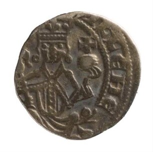
Münze, Pfennig, 1247 - 1256
Münze, Pfennig, 1247 - 1256
Münze, Pfennig, 1247 - 1256
Untere Havelwasserstraße km neu 44,5 - 45,2; km alt 124,1 - 124,7 (Brandenburger Havel)
Untere Havelwasserstraße km neu 43,2 - 43,6; km alt 125,6 - 125,9 (Brandenburger Havel)
König Wilhelm von Holland : 1247 - 1256, 1. 1247
Unterer Havelwasserstraße km neu 125,6 - 126,8; Nebenblatt km alt 35,4 - 37,0 (Gülper Havel)
Untere Havelwasserstraße, Km 137 - 163
Obere Havelwasserstraße km 0 bis km 60,7
Untere Havelwasserstraße. Km 115,1 - Km 117,4
Regnum statt Interregnum : König Wilhelm, 1247–1256
Unterer Havelwasserstraße km neu 125,6 - 126,1; km alt 36,1 - 37
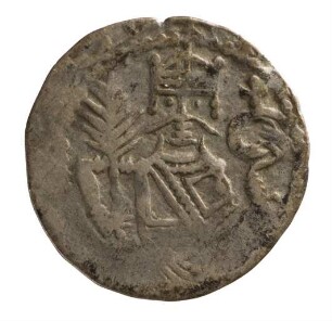
Münze, Pfennig, 1247 - 1256
Münze, Pfennig, 1247 - 1256
Münze, Pfennig, 1247 - 1256
Untere Havelwasserstraße km neu 44,5 - 45,2; km alt 124,1 - 124,7 (Brandenburger Havel)
Untere Havelwasserstraße km neu 43,2 - 43,6; km alt 125,6 - 125,9 (Brandenburger Havel)
König Wilhelm von Holland : 1247 - 1256, 1. 1247
Unterer Havelwasserstraße km neu 125,6 - 126,8; Nebenblatt km alt 35,4 - 37,0 (Gülper Havel)
Untere Havelwasserstraße, Km 137 - 163
Obere Havelwasserstraße km 0 bis km 60,7
Untere Havelwasserstraße. Km 115,1 - Km 117,4
Regnum statt Interregnum : König Wilhelm, 1247–1256
Unterer Havelwasserstraße km neu 125,6 - 126,1; km alt 36,1 - 37
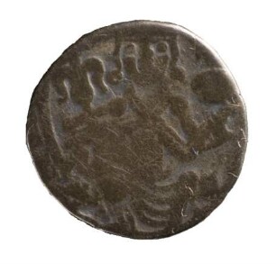
Münze, Pfennig, 1247 - 1256
Münze, Pfennig, 1247 - 1256
Münze, Pfennig, 1247 - 1256
Untere Havelwasserstraße km neu 44,5 - 45,2; km alt 124,1 - 124,7 (Brandenburger Havel)
Untere Havelwasserstraße km neu 43,2 - 43,6; km alt 125,6 - 125,9 (Brandenburger Havel)
König Wilhelm von Holland : 1247 - 1256, 1. 1247
Unterer Havelwasserstraße km neu 125,6 - 126,8; Nebenblatt km alt 35,4 - 37,0 (Gülper Havel)
Untere Havelwasserstraße, Km 137 - 163
Obere Havelwasserstraße km 0 bis km 60,7
Untere Havelwasserstraße. Km 115,1 - Km 117,4