- Alternative title
-
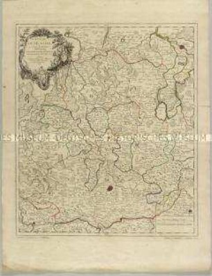
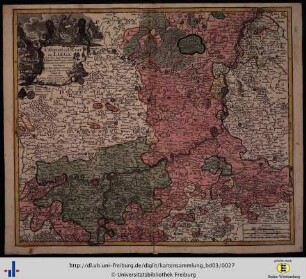
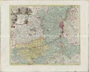
CARTE / DE / L'EVÊCHÉ / DE
- Location
-
Deutsches Historisches Museum, Berlin
- Inventory number
-
Do 2006/630
- Measurements
-
Höhe x Breite: 58,5 x 72 cm (Blatt)
Höhe x Breite: 44,4 x 53,4 cm (Karte)
Höhe x Breite: 47,6 x 56,5 cm (Platte)
- Material/Technique
-
Papier, Kupferstich, koloriert
- Classification
-
Kartografie (Gattung)
- Subject (what)
-
Paderborn
- Event
-
Herstellung
- (who)
-
Stecher, Verleger, Geograph: Tobias Konrad Lotter
Marquis, Kartograf: Louis Francois de la Rozière Carlet
- (where)
-
Augsburg, Deutschland
- (when)
-
1762
- Rights
-
Deutsches Historisches Museum
- Last update
-
24.03.2023, 9:29 AM CET
Data provider
This object is provided by:
Stiftung Deutsches Historisches Museum. If you have any questions about the object, please contact the data provider.
Stiftung Deutsches Historisches Museum. If you have any questions about the object, please contact the data provider.
Object type
- Diözesankarte
Associated
- Stecher, Verleger, Geograph: Tobias Konrad Lotter
- Marquis, Kartograf: Louis Francois de la Rozière Carlet
Time of origin
- 1762
Other Objects (12)
L'Eveché de Munster
Monnaies de l'évéché de Sion
Monnaies de l'évéché de Lausanne
Histoire de l'évêché de Bethléem

Bl. LXV: L'Eveché de Hildesheim.
Les Chroniques de l'évêché de Langres
L'Eveche et l'Etat de Liege
L'Eveche et l'Etat de Liege
BASSE PARTIE DE L'EVECHÉ DE MÜNSTER
Études sur les origines de l'évêché de Bayeux, I
Table des Titres de la Coûtume de l'Évêché de Metz.
Jean de Vienne, ou l'évêché de Bale au XIV. siècle
L'Eveché de Munster
Monnaies de l'évéché de Sion
Monnaies de l'évéché de Lausanne
Histoire de l'évêché de Bethléem
Bl. LXV: L'Eveché de Hildesheim.
Les Chroniques de l'évêché de Langres
L'Eveche et l'Etat de Liege
L'Eveche et l'Etat de Liege
BASSE PARTIE DE L'EVECHÉ DE MÜNSTER
Études sur les origines de l'évêché de Bayeux, I
Table des Titres de la Coûtume de l'Évêché de Metz.