Verzeichnung
Karte vom Stollhammer Groden, Jade, Seefelder Groden Maßstab: 1:8000 Vermesser/Zeichner: J. W. A. Hunrichs
- Reference number
-
NLA OL, K-ZE, Best. 298 C IX Nr. 4
- Further information
-
Identifikation: Band:
- Context
-
Zentraler Kartenbestand Oldenburg >> 5 Bezirksregierung Weser-Ems >> 5.19 Ehemaliger Verwaltungsbezirk Oldenburg bzw. dessen Vorgängerstaaten >> 5.19.6 Deiche und Anwächse, Geländeprofile >> 5.19.6.1 Watt- und Grodenkarten
- Holding
-
NLA OL, K-ZE Zentraler Kartenbestand Oldenburg
- Indexentry person
-
Hunrichs, J. W. A., Zeichner
- Indexentry place
-
Jade, Fluss
Seefelder Groden, Karte
Stollhammer Groden, Karte
- Date of creation
-
- 1742
- Other object pages
- Last update
-
16.06.2025, 11:08 AM CEST
Data provider
This object is provided by:
Niedersächsisches Landesarchiv. If you have any questions about the object, please contact the data provider.
Niedersächsisches Landesarchiv. If you have any questions about the object, please contact the data provider.
Object type
- Verzeichnung
Time of origin
- - 1742
Other Objects (12)

Plan des Seefelder Groden, Jade Maßstab: 1:2000 Vermesser/Zeichner: G. N. von Lindelof
Karte vom Seefelder und Stollhammer Groden Maßstab: 1:8000 Vermesser/Zeichner: J. W. A. Hunrichs
Karte des Seefelder und Stollhammer Groden Maßstab: 1:4000 Vermesser/Zeichner: Peters
Karte vom Südender Groden (Varel) Eytings Groden Maßstab: 1:4000 Vermesser/Zeichner: Behrens
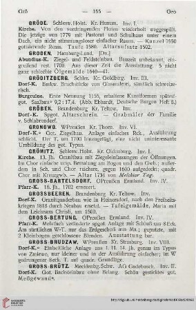
⟦Groden⟧

⟦Groden⟧
Vom Vorlande des Anwachses, vom neu eingedeichten Wapeler Groden, oder vom Wapeler Außendeichs-Groden, Vogtei Jade
Vom Vorlande des Anwachses, vom neu eingedeichten Wapeler Groden, oder vom Wapeler Außendeichs-Groden, Vogtei Jade
Burwinkeler Groden
Sandumer Groden
Archivpflege Groden
Siegel Groden
Plan des Seefelder Groden, Jade Maßstab: 1:2000 Vermesser/Zeichner: G. N. von Lindelof
Karte vom Seefelder und Stollhammer Groden Maßstab: 1:8000 Vermesser/Zeichner: J. W. A. Hunrichs
Karte des Seefelder und Stollhammer Groden Maßstab: 1:4000 Vermesser/Zeichner: Peters
Karte vom Südender Groden (Varel) Eytings Groden Maßstab: 1:4000 Vermesser/Zeichner: Behrens
⟦Groden⟧
⟦Groden⟧
Vom Vorlande des Anwachses, vom neu eingedeichten Wapeler Groden, oder vom Wapeler Außendeichs-Groden, Vogtei Jade
Vom Vorlande des Anwachses, vom neu eingedeichten Wapeler Groden, oder vom Wapeler Außendeichs-Groden, Vogtei Jade
Burwinkeler Groden
Sandumer Groden
Archivpflege Groden