- Alternative title
-
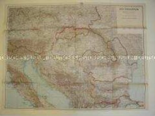
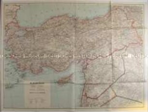
Südeuropa (Ost-Blatt)
- Location
-
Deutsches Historisches Museum, Berlin
- Inventory number
-
Do2 2001/112
- Measurements
-
Höhe x Breite: 29,7 x 21,8 cm (gefaltet), Höhe x Breite: 87 x 119,5 cm (aufgeschlagen)
- Material/Technique
-
Papier, gedruckt
- Classification
-
Kartografie (Gattung)
- Subject (what)
-
Geographie
- Event
-
Herstellung
- (who)
-
Verleger: Justus Perthes
- (where)
-
Gotha, Deutschland [historisch: Deutsches Reich]
- (when)
-
um 1940
- Rights
-
Deutsches Historisches Museum
- Last update
-
24.03.2023, 9:29 AM CET
Data provider
This object is provided by:
Stiftung Deutsches Historisches Museum. If you have any questions about the object, please contact the data provider.
Stiftung Deutsches Historisches Museum. If you have any questions about the object, please contact the data provider.
Object type
- Politisch-geografische Karte
Associated
- Verleger: Justus Perthes
Time of origin
- um 1940
Other Objects (12)
Politisch-geografische Karte aus dem 2. Weltkrieg
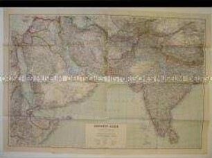
Politisch-geografische Karte von Asien aus dem 2. Weltkrieg
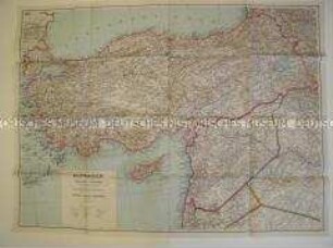
Politisch-geografische Karte von Kleinasien aus dem 2. Weltkrieg
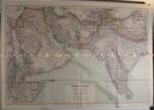
Politisch-geografische Karte von Südwest-Asien und Arabien
Politisch-geografische Karte von Kleinasien aus der Zeit des 2. Weltkrieges
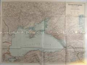
Politisch-geografische Karte des Schwarzmeerraumes aus der Zeit des 2. Weltkrieges
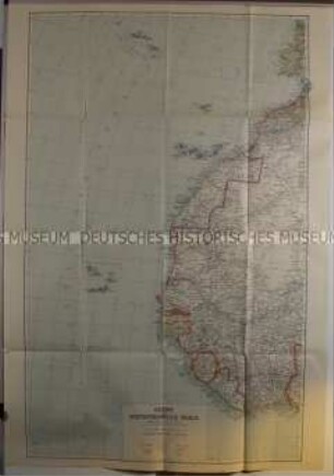
Politisch-geografische Karte der Azoren und Westafrikanischen Inseln aus der Zeit des 2. Weltkrieges
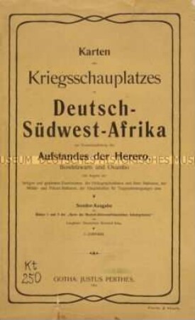
Karten des Kriegsschauplatzes in Deutsch-Südwest-Afrika

"Bundesrepublik Deutschland" physisch und politisch Ausf.-Art: Farbiger Druck Herst.: Justus Perthes Format: 123 x 99,5 cm Maßstab: 1 : 830 000
"Bundesrepublik Deutschland" physisch und politisch Ausf.-Art: Farbiger Druck Herst.: Justus Perthes Format: 123 x 99,5 cm Maßstab: 1 : 830 000
"Bundesrepublik Deutschland" physisch und politisch Ausf.-Art: Farbiger Druck Herst.: Justus Perthes Format: 123 x 99,5 cm Maßstab: 1 : 830 000
"Bundesrepublik Deutschland" physisch und politisch Ausf.-Art: Farbiger Druck Herst.: Justus Perthes Format: 123 x 99,5 cm Maßstab: 1 : 830 000
Politisch-geografische Karte aus dem 2. Weltkrieg
Politisch-geografische Karte von Asien aus dem 2. Weltkrieg
Politisch-geografische Karte von Kleinasien aus dem 2. Weltkrieg
Politisch-geografische Karte von Südwest-Asien und Arabien
Politisch-geografische Karte von Kleinasien aus der Zeit des 2. Weltkrieges
Politisch-geografische Karte des Schwarzmeerraumes aus der Zeit des 2. Weltkrieges
Politisch-geografische Karte der Azoren und Westafrikanischen Inseln aus der Zeit des 2. Weltkrieges
Karten des Kriegsschauplatzes in Deutsch-Südwest-Afrika
"Bundesrepublik Deutschland" physisch und politisch Ausf.-Art: Farbiger Druck Herst.: Justus Perthes Format: 123 x 99,5 cm Maßstab: 1 : 830 000
"Bundesrepublik Deutschland" physisch und politisch Ausf.-Art: Farbiger Druck Herst.: Justus Perthes Format: 123 x 99,5 cm Maßstab: 1 : 830 000
"Bundesrepublik Deutschland" physisch und politisch Ausf.-Art: Farbiger Druck Herst.: Justus Perthes Format: 123 x 99,5 cm Maßstab: 1 : 830 000
"Bundesrepublik Deutschland" physisch und politisch Ausf.-Art: Farbiger Druck Herst.: Justus Perthes Format: 123 x 99,5 cm Maßstab: 1 : 830 000
Politisch-geografische Karte aus dem 2. Weltkrieg
Politisch-geografische Karte von Asien aus dem 2. Weltkrieg
Politisch-geografische Karte von Kleinasien aus dem 2. Weltkrieg
Politisch-geografische Karte von Südwest-Asien und Arabien
Politisch-geografische Karte von Kleinasien aus der Zeit des 2. Weltkrieges
Politisch-geografische Karte des Schwarzmeerraumes aus der Zeit des 2. Weltkrieges
Politisch-geografische Karte der Azoren und Westafrikanischen Inseln aus der Zeit des 2. Weltkrieges
Karten des Kriegsschauplatzes in Deutsch-Südwest-Afrika
"Bundesrepublik Deutschland" physisch und politisch Ausf.-Art: Farbiger Druck Herst.: Justus Perthes Format: 123 x 99,5 cm Maßstab: 1 : 830 000
"Bundesrepublik Deutschland" physisch und politisch Ausf.-Art: Farbiger Druck Herst.: Justus Perthes Format: 123 x 99,5 cm Maßstab: 1 : 830 000
"Bundesrepublik Deutschland" physisch und politisch Ausf.-Art: Farbiger Druck Herst.: Justus Perthes Format: 123 x 99,5 cm Maßstab: 1 : 830 000