Karte / Plan
Dülken Land, Katasterkarte Flur 2, Bl. 1 (am Steenpfad, an Mees Kirchweg, am Meesbüschgen, Karmannshof, Derkes Hütt)
- Reference number
-
136
- Further information
-
Standort: 26.20
Maßstab: 1:2.500
- Context
-
Karten und Pläne Stadt Viersen >> 2. Dülken >> 2.1. Kataster Dülken
- Holding
-
S 2c Karten und Pläne Stadt Viersen Karten und Pläne Stadt Viersen
- Indexentry place
-
Am Steenpfad
An Mees Kirchweg
Am Meesbüschgen
Karmannshof
Derkes Hütt
- Other object pages
- Delivered via
- Last update
-
17.09.2025, 3:27 PM CEST
Data provider
This object is provided by:
Kreisarchiv Viersen. If you have any questions about the object, please contact the data provider.
Kreisarchiv Viersen. If you have any questions about the object, please contact the data provider.
Object type
- Karten und Pläne
Other Objects (12)

Dülken Land, Katasterkarte Flur 9, Bl. 1 (am Hensenhof, Rungeraths Hütt, Eickenpeschen, am Bäckerssträßchen, auf Schinken Rost, Eckskes Peschen, Peschfeld, am Klemens Fichten, am Schauertssträßchen, Mackensteiner Kirchweg)
Heinrich Mees [- Am Rohrbuschweg]
Kirchweg, am
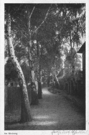
Am Kirchweg
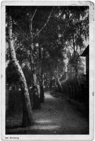
Am Kirchweg
Hütt, Richard
Hütt, Johann
Hütt, Paul
Hütt, Michael
Hütt, Fritz
Hütt, Karl

Wolfgang Hütt
Dülken Land, Katasterkarte Flur 9, Bl. 1 (am Hensenhof, Rungeraths Hütt, Eickenpeschen, am Bäckerssträßchen, auf Schinken Rost, Eckskes Peschen, Peschfeld, am Klemens Fichten, am Schauertssträßchen, Mackensteiner Kirchweg)
Heinrich Mees [- Am Rohrbuschweg]
Kirchweg, am
Am Kirchweg
Am Kirchweg
Hütt, Richard
Hütt, Johann
Hütt, Paul
Hütt, Michael
Hütt, Fritz
Hütt, Karl