Karten und Pläne
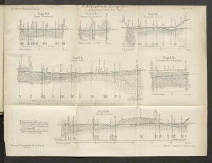
Ahrein (LK Miesbach). Hydrographische Karte der Leizach zwischen Lehenpoint und Obermühle nächst Ahrein
- Reference number
-
StAM, Plansammlung 547
- Former reference number
-
K 20/10
- Dimensions
-
177 cm x 57 cm
- Formal description
-
1 : 2500; Federzeichnung koloriert
- Language of the material
-
deutsch
- Context
-
Plansammlung >> Plansammlung >> 1. Plansammlung 1-4191 (Retrokonvertiertes Findmittel) >> 1.1. Allgemeine Plansammlung
- Holding
-
StAM, Plansammlung Plansammlung
- Date of creation
-
1848
- Other object pages
- Last update
-
22.04.2025, 1:53 PM CEST
Data provider
This object is provided by:
Staatsarchiv München. If you have any questions about the object, please contact the data provider.
Staatsarchiv München. If you have any questions about the object, please contact the data provider.
Object type
- Karten und Pläne
Time of origin
- 1848
Other Objects (12)
Hydrographische bijzonderheden
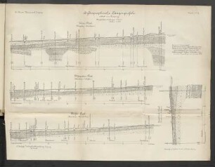
Hydrographische Längenprofile

Hydrographische Angelegenheiten
Hydrographische Theilung.
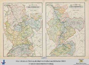
Hydrographische Übersichtskarte

Hydrographische Verhältnisse.
Hydrographische bijzonderheden
Hydrographische Querprofile
Hydrographische Jahresberichte
Obermühle; Braunfels, Obermühle 1, Obermühle 3, Obermühle
Obermühle; Hammersbach, Obermühle
Landrat Miesbach, Bieraufschlag, Miesbach
Hydrographische bijzonderheden
Hydrographische Längenprofile
Hydrographische Angelegenheiten
Hydrographische Theilung.
Hydrographische Übersichtskarte
Hydrographische Verhältnisse.
Hydrographische bijzonderheden
Hydrographische Querprofile
Hydrographische Jahresberichte
Obermühle; Braunfels, Obermühle 1, Obermühle 3, Obermühle
Obermühle; Hammersbach, Obermühle