- Alternative title
-
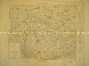
Karte der Umgebung von Cöln
- Location
-
Deutsches Historisches Museum, Berlin
- Inventory number
-
Do 83/185I
- Measurements
-
Höhe x Breite: 70 x 68 cm
- Material/Technique
-
Papier, gedruckt
- Classification
-
Kartografie (Gattung)
- Subject (what)
-
Topographie
- Event
-
Herstellung
- (who)
-
Herausgeber: Preußische Landesaufnahme
- (where)
-
Berlin, Deutschland [historisch: Deutsches Reich]
- (when)
-
1920
- Rights
-
Deutsches Historisches Museum
- Last update
-
24.03.2023, 9:31 AM CET
Data provider
This object is provided by:
Stiftung Deutsches Historisches Museum. If you have any questions about the object, please contact the data provider.
Stiftung Deutsches Historisches Museum. If you have any questions about the object, please contact the data provider.
Object type
- Topographische Karte
Associated
- Herausgeber: Preußische Landesaufnahme
Time of origin
- 1920
Other Objects (12)

Topographische Karte von Verden und Umgebung
Topographische Karte des Erzgebirges
Topographische Karte der Alpen
Topographische Karte des Bayerischen Hochlandes
Topographische Karte des Truppenübungsplatzes Ohrdruf
Topographische Karte des östlichen Erzgebirges
Topographische Karte des Kreises Crossen
Topographische Karte des Amtsbezirkes Mannheim
Topographische Karte des Truppenübungsplatzes Münsingen
Topographische Karte des Truppenübungsplatzes Zossen
Topographische Karte des Kreises Grimmen
Topographische Karte des Amtsbezirkes Müllheim
Topographische Karte von Verden und Umgebung
Topographische Karte des Erzgebirges
Topographische Karte der Alpen
Topographische Karte des Bayerischen Hochlandes
Topographische Karte des Truppenübungsplatzes Ohrdruf
Topographische Karte des östlichen Erzgebirges
Topographische Karte des Kreises Crossen
Topographische Karte des Amtsbezirkes Mannheim
Topographische Karte des Truppenübungsplatzes Münsingen
Topographische Karte des Truppenübungsplatzes Zossen
Topographische Karte des Kreises Grimmen