Karte / Plan
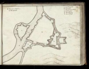
Karte von Frankreich 1:80.000. Gruppe II: Chalons-sur-Saone 137 B. [Kartographische Abtheilung der Königl. Preuss. Landes-Aufnahme]
- Reference number
-
RW Karten, 7041
- Dimensions
-
Maßstab: 1:80.000
- Context
-
RW Karten >> 1. Topographische Karten >> 1.3. Landesaufnahme Ausland >> 1.3.3. Europa >> 1.3.3.3. Frankreich
- Holding
-
RW Karten
- Date of creation
-
1915/1916
- Other object pages
- Provenance
-
Diverse Registraturbildner
- Delivered via
- Last update
-
17.09.2025, 2:55 PM CEST
Data provider
This object is provided by:
Landesarchiv Nordrhein-Westfalen. Abteilung Rheinland. If you have any questions about the object, please contact the data provider.
Landesarchiv Nordrhein-Westfalen. Abteilung Rheinland. If you have any questions about the object, please contact the data provider.
Object type
- Karten / Pläne
Time of origin
- 1915/1916
Other Objects (12)
![Karte von Frankreich 1:80.000. Gruppe II: Chalons-sur-Saone 137 C. [Kartographische Abtheilung der Königl. Preuss. Landes-Aufnahme]](https://iiif.deutsche-digitale-bibliothek.de/image/2/96efbdb6-4f5e-4440-b7bf-a322ec60b970/full/!306,450/0/default.jpg)
Karte von Frankreich 1:80.000. Gruppe II: Chalons-sur-Saone 137 C. [Kartographische Abtheilung der Königl. Preuss. Landes-Aufnahme]
![Karte von Frankreich 1:80.000. Gruppe II: Chalons-sur-Saone 137 A. [Kartographische Abtheilung der Königl. Preuss. Landes-Aufnahme]](https://iiif.deutsche-digitale-bibliothek.de/image/2/94de9ee6-5f2d-431e-860e-e5695859ffb6/full/!306,450/0/default.jpg)
Karte von Frankreich 1:80.000. Gruppe II: Chalons-sur-Saone 137 A. [Kartographische Abtheilung der Königl. Preuss. Landes-Aufnahme]
![Karte von Frankreich 1:80.000. Gruppe II: Chalons-sur-Saone 137 D. [Kartographische Abtheilung der Königl. Preuss. Landes-Aufnahme]](https://iiif.deutsche-digitale-bibliothek.de/image/2/7596e543-6618-4d6a-b1ae-73a5705e609b/full/!306,450/0/default.jpg)
Karte von Frankreich 1:80.000. Gruppe II: Chalons-sur-Saone 137 D. [Kartographische Abtheilung der Königl. Preuss. Landes-Aufnahme]

Städtepartnerschaft: Chalon-sur-Saône: Messe in Chalon-sur-Saône
Chalon-sur-Saône
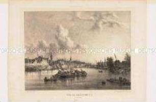
Chalon-sur-Saône
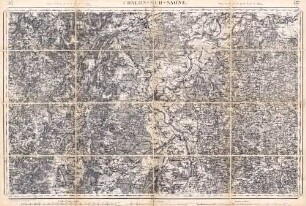
Umgebungskarte (1:80.000)
137 Chalon-sur-Saone
Städtepartnerschaft: Chalon-sur-Saône
Medaille Chalon-sur-Saône
Städtepartnerschaft: Chalon-sur-Saône
Städtepartnerschaft: Chalon-sur-Saône
Karte von Frankreich 1:80.000. Gruppe II: Chalons-sur-Saone 137 C. [Kartographische Abtheilung der Königl. Preuss. Landes-Aufnahme]
Karte von Frankreich 1:80.000. Gruppe II: Chalons-sur-Saone 137 A. [Kartographische Abtheilung der Königl. Preuss. Landes-Aufnahme]
Karte von Frankreich 1:80.000. Gruppe II: Chalons-sur-Saone 137 D. [Kartographische Abtheilung der Königl. Preuss. Landes-Aufnahme]
Städtepartnerschaft: Chalon-sur-Saône: Messe in Chalon-sur-Saône
Chalon-sur-Saône
Chalon-sur-Saône
Umgebungskarte (1:80.000)
137 Chalon-sur-Saone
Städtepartnerschaft: Chalon-sur-Saône
Medaille Chalon-sur-Saône
Städtepartnerschaft: Chalon-sur-Saône