- Reference number
-
D 73, 8/216
- Dimensions
-
Höhe: 150 cm, Breite: 200 cm, Maßstab: 1 : 3 000 000
- Context
-
Allgemeine Kartensammlung (Schulwandkarten) >> 1. Geschichte >> 1.1. Karten
- Holding
-
D 73 Allgemeine Kartensammlung (Schulwandkarten)
- Date of creation
-
ca. 1910
- Other object pages
- Provenance
-
Behörden, Institutionen, Einzelpersonen (Sammlungen)
- Delivered via
- Last update
-
17.09.2025, 2:37 PM CEST
Data provider
This object is provided by:
Landesarchiv Nordrhein-Westfalen. Abteilung Ostwestfalen-Lippe. If you have any questions about the object, please contact the data provider.
Landesarchiv Nordrhein-Westfalen. Abteilung Ostwestfalen-Lippe. If you have any questions about the object, please contact the data provider.
Object type
- Karten / Pläne
Time of origin
- ca. 1910
Other Objects (12)
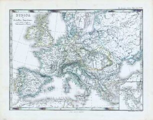
Europa im Zeitalter Napoleons
Europa im Zeitalter Napoleons
Europa im Zeitalter Napoleons.

Europa Türkei Geschichtskarte Zeitalter Napoleons 1836 o.M. 32 x 48 kol. Stich: B. Herder, Freiburg Julius Loewenberg B Nr. 260

Zeitalter Napoleons I.: Bd. 4: Weltgeschichte im Zeitalter Napoleons I.
Ostfriesland im Zeitalter Napoleons
Das Zeitalter der Entdeckungen
Deutschland und Italien im Zeitalter der Hohenstaufen
Das Zeitalter Napoleons

Das Zeitalter Napoleons
Karte: Das Zeitalter der Entdeckungen
Deutschland im Zeitalter der nationalen Wiedergeburt, 1815-1866
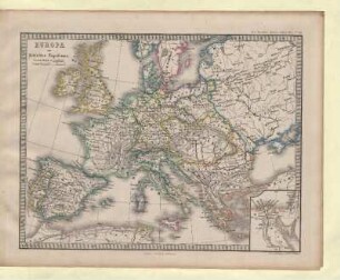
Europa im Zeitalter Napoleons
Europa im Zeitalter Napoleons
Europa im Zeitalter Napoleons.
Europa Türkei Geschichtskarte Zeitalter Napoleons 1836 o.M. 32 x 48 kol. Stich: B. Herder, Freiburg Julius Loewenberg B Nr. 260
Zeitalter Napoleons I.: Bd. 4: Weltgeschichte im Zeitalter Napoleons I.
Ostfriesland im Zeitalter Napoleons
Das Zeitalter der Entdeckungen
Deutschland und Italien im Zeitalter der Hohenstaufen
Das Zeitalter Napoleons
Das Zeitalter Napoleons
Karte: Das Zeitalter der Entdeckungen
Deutschland im Zeitalter der nationalen Wiedergeburt, 1815-1866
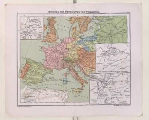
Europa im Zeitalter Napoleons
Europa im Zeitalter Napoleons
Europa im Zeitalter Napoleons.
Europa Türkei Geschichtskarte Zeitalter Napoleons 1836 o.M. 32 x 48 kol. Stich: B. Herder, Freiburg Julius Loewenberg B Nr. 260
Zeitalter Napoleons I.: Bd. 4: Weltgeschichte im Zeitalter Napoleons I.
Ostfriesland im Zeitalter Napoleons
Das Zeitalter der Entdeckungen
Deutschland und Italien im Zeitalter der Hohenstaufen
Das Zeitalter Napoleons
Das Zeitalter Napoleons
Karte: Das Zeitalter der Entdeckungen