Karte / Plan
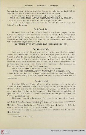
Schüttorf (Schüttorf) Stadtplan mit Straßenverzeichnis um 1960 1 : 7500 58 x 44 farb. Druck: Verwaltungsverlag Walter Hienz B Nr. 1279
- Former reference number
-
B 1279
- Further information
-
Ort: Schüttorf, Schüttorf
- Context
-
Karten A (Allgemein) >> 1. Topographische Karte, Übersichtskarten >> 1.5. Stadt-/ Ortspläne
- Holding
-
W 051 Karten A (Allgemein)
- Indexentry place
-
Schüttorf, Schüttorf
Schüttorf, Stadtplan, 1960
- Date of creation
-
1960
- Other object pages
- Provenance
-
Sammlungsregistraturbildner
- Delivered via
- Last update
-
17.09.2025, 3:39 PM CEST
Data provider
This object is provided by:
Landesarchiv Nordrhein-Westfalen. Abteilung Westfalen. If you have any questions about the object, please contact the data provider.
Landesarchiv Nordrhein-Westfalen. Abteilung Westfalen. If you have any questions about the object, please contact the data provider.
Object type
- Karten / Pläne
Time of origin
- 1960
Other Objects (12)

Schüttorf
Schüttorf
⟦Schüttorf⟧
Schüttorf
Schüttorf
Hannover: Schüttorf
3609 Schüttorf
Schüttorf: Armenwesen

Schüttorf (b. Bentheim)
Blatt 3609 Schüttorf
Familienforschung Leisting, Schüttorf
Schüttorf: Städtisches Krankenhaus
Schüttorf
Schüttorf
⟦Schüttorf⟧
Schüttorf
Schüttorf
Hannover: Schüttorf
3609 Schüttorf
Schüttorf: Armenwesen
Schüttorf (b. Bentheim)
Blatt 3609 Schüttorf
Familienforschung Leisting, Schüttorf
Schüttorf: Städtisches Krankenhaus
Schüttorf
Schüttorf
⟦Schüttorf⟧
Schüttorf
Schüttorf
Hannover: Schüttorf
3609 Schüttorf
Schüttorf: Armenwesen
Schüttorf (b. Bentheim)
Blatt 3609 Schüttorf
Familienforschung Leisting, Schüttorf