- Alternative title
-
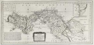
CARTA MARITIMA / DEL REYNO DE / TIERRA FIRME Ú CASTILLA DEL ORO. / COMPREHENDE EL ISTMO Y PROVINCIA
- Location
-
Deutsches Historisches Museum, Berlin
- Inventory number
-
Do 2006/1165.1-2
- Measurements
-
Höhe x Breite: 46 x 59,5 cm (Blatt 1)
Höhe x Breite: 34,2 x 38 cm (Karte 1)
Höhe x Breite: 39 x 41,5 cm (Platte 1)
Höhe x Breite: 46,5 x 60,5 cm (Blatt 2)
Höhe x Breite: 34,2 x 38 cm (Karte 2)
Höhe x Breite: 39 x 41,5 cm (Platte 2)
- Material/Technique
-
Papier, Kupferstich, koloriert
- Classification
-
Kartografie (Gattung)
- Subject (what)
-
Mittelamerika
Panama
- Event
-
Herstellung
- (who)
-
Kartograf, Geograph: Juan Lopez
- (where)
-
Madrid, Spanien
- (when)
-
1785
- Rights
-
Deutsches Historisches Museum
- Last update
-
2023-03-24T09:27:36+0100
Data provider
This object is provided by:
Stiftung Deutsches Historisches Museum. If you have any questions about the object, please contact the data provider.
Stiftung Deutsches Historisches Museum. If you have any questions about the object, please contact the data provider.
Object type
- Küstenkarte
Associated
- Kartograf, Geograph: Juan Lopez
Time of origin
- 1785
Other Objects (12)

Carta Maritima Del Reyno De Tierra Firme Ú Castilla Del Oro : Comprehende Il Istmo Y Provincia e Panamá : las Provincias de Veragua, Darien y Biruquete
Historia del Origen y Soberania del Condado y Reyno de Castilla
Karte von Panama "Carta maritima del reyno de Tierra firmo ..."
Sumaria descrición del Reyno de Tierra Firme llamado Castilla del Oro, questá subjeto á la Real audiencia de la cuidad de Panamá. - Año de 1575 (1).
![Descripcion Del Reyno De Aragon : [gewidmet:] Dipvtados Del Reyno De Aragon](https://iiif.deutsche-digitale-bibliothek.de/image/2/03ae9471-7b8e-4918-99a7-44b639f02ef6/full/!306,450/0/default.jpg)
Descripcion Del Reyno De Aragon : [gewidmet:] Dipvtados Del Reyno De Aragon
Mapa Del Reyno Balearico
Fueros del reyno de Navarra : desde su creacion, hasta su feliz union con el de Castilla
Historia del reyno de Portugal ...
Descripcion del Reyno de Galicia
Libro del reyno de Dios

Mapa Del Reyno De Cordova

Mapa Del Reyno De Algarve
Carta Maritima Del Reyno De Tierra Firme Ú Castilla Del Oro : Comprehende Il Istmo Y Provincia e Panamá : las Provincias de Veragua, Darien y Biruquete
Historia del Origen y Soberania del Condado y Reyno de Castilla
Karte von Panama "Carta maritima del reyno de Tierra firmo ..."
Sumaria descrición del Reyno de Tierra Firme llamado Castilla del Oro, questá subjeto á la Real audiencia de la cuidad de Panamá. - Año de 1575 (1).
Descripcion Del Reyno De Aragon : [gewidmet:] Dipvtados Del Reyno De Aragon
Mapa Del Reyno Balearico
Fueros del reyno de Navarra : desde su creacion, hasta su feliz union con el de Castilla
Historia del reyno de Portugal ...
Descripcion del Reyno de Galicia
Libro del reyno de Dios
Mapa Del Reyno De Cordova