- Alternative title
-
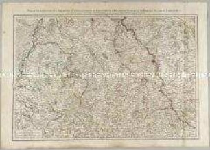
LE ROYAUME / D'ANGLETERRE, / divisé selon les sept Royaumes, / ou Heptarchie des Saxons,
- Location
-
Deutsches Historisches Museum, Berlin
- Inventory number
-
Do 2006/871
- Measurements
-
Höhe x Breite: 55 x 78 cm (Blatt)
Höhe x Breite: 45,5 x 49 cm (Karte)
Höhe x Breite: 48,3 x 52,3 cm (Platte)
- Material/Technique
-
Papier, Kupferstich, grenzkoloriert
- Classification
-
Kartografie (Gattung)
- Subject (what)
-
Großbritannien
- Event
-
Herstellung
- (who)
-
Kartograf, Geograph: Didier Robert de Vaugondy
Stecher, Kartograf: Paolo Santini
Kartograf, Verleger: Giuseppe Antonio Remondini
- (where)
-
Venedig, Italien
- (when)
-
um 1778
- Rights
-
Deutsches Historisches Museum
- Last update
-
24.03.2023, 9:30 AM CET
Data provider
This object is provided by:
Stiftung Deutsches Historisches Museum. If you have any questions about the object, please contact the data provider.
Stiftung Deutsches Historisches Museum. If you have any questions about the object, please contact the data provider.
Object type
- Verwaltungskarte
Associated
- Kartograf, Geograph: Didier Robert de Vaugondy
- Stecher, Kartograf: Paolo Santini
- Kartograf, Verleger: Giuseppe Antonio Remondini
Time of origin
- um 1778
Other Objects (12)
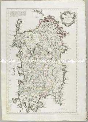
Le Royaume de Sardaigne
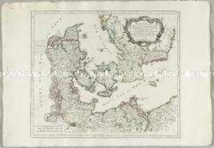
Royaume de Danemarck
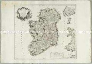
Royaume d'Irlande
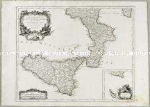
Partie Méridionale du Royaume de Naples. Mit einer Nebenkarte: Supplement pour l'Isle de Malte
Partie Meridionale de l'Archevesché et Eslectorat de Cologne, des Duchés de Iuliers et de Berg, le Duché de Limbourg, &c.
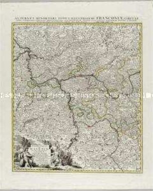
Grand Theatre de la Guerre: L'Electorat de Mayence, le Bas Palatinat et une partie du pays de Hesse et de la rivière du Mein
Atlas Nouveau: Gouvernement de Bearn
![Karte von Hessen (südliche Nassauische Fürstentümer), 1:350 000, Kupferstich, um 1740 : Moguntini Archiepiscopat' et Electoratus : nec non Comitatuum Utriusque Cattimeliboci Verthemensis, & Erpachiensis aliarumque insertarum & adjacentium Regionum accuratißima Descriptio : cum Privil. Ordin. General. Belgii Foederati / per Nic. Visscher, Nunc apud Petr. Schenk Iunior, G. Gouwen s.. - [Ca. 1:350 000] (E 007 30 -E 009 44 /N 050 32 -N 049 17). - Amst. Bat. : Petr. Schenk Iunior , [um 1740]. - 1 Karte : Kupferstich ; 46 x 58 cm, Blattgröße 54 x 63 cm. - Nullmeridian:St. Miguel. - Titelkartusche geschmückt mit Wappen u. allegor. Darst. oben rechts. - Erklärungs- u. Maßstabskartusche geschmückt mit allegor. Darst. unten links. - Stecher in Titelkartusche unten](https://iiif.deutsche-digitale-bibliothek.de/image/2/406bf9f8-e0ab-4859-8cbb-848d71e95444/full/!306,450/0/default.jpg)
Karte von Hessen (südliche Nassauische Fürstentümer), 1:350 000, Kupferstich, um 1740 : Moguntini Archiepiscopat' et Electoratus : nec non Comitatuum Utriusque Cattimeliboci Verthemensis, & Erpachiensis aliarumque insertarum & adjacentium Regionum accuratißima Descriptio : cum Privil. Ordin. General. Belgii Foederati / per Nic. Visscher, Nunc apud Petr. Schenk Iunior, G. Gouwen s.. - [Ca. 1:350 000] (E 007 30 -E 009 44 /N 050 32 -N 049 17). - Amst. Bat. : Petr. Schenk Iunior , [um 1740]. - 1 Karte : Kupferstich ; 46 x 58 cm, Blattgröße 54 x 63 cm. - Nullmeridian:St. Miguel. - Titelkartusche geschmückt mit Wappen u. allegor. Darst. oben rechts. - Erklärungs- u. Maßstabskartusche geschmückt mit allegor. Darst. unten links. - Stecher in Titelkartusche unten
Atlas Nouveau: Gouvernement du Comté de Foix

Topographische Karte der Gegend östlich von Emmendingen zwischen Dörlinbach, Prechtal, Elzach, Triberg, Furtwangen, St. Peter und Freiburg im Breisgau, heute Südlicher Oberrhein und Regierungsbezirk Freiburg
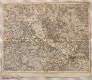
Topographische Karte des Elbetals und Umgebung nordwestlich von Dresden in Sachsen
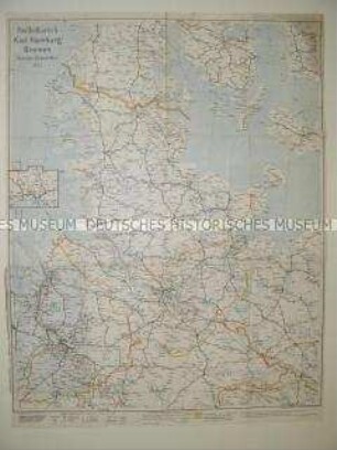
Administrative Karte von Norddeutschland mit den Postleitgebieten
Le Royaume de Sardaigne
Royaume de Danemarck
Royaume d'Irlande
Partie Méridionale du Royaume de Naples. Mit einer Nebenkarte: Supplement pour l'Isle de Malte
Partie Meridionale de l'Archevesché et Eslectorat de Cologne, des Duchés de Iuliers et de Berg, le Duché de Limbourg, &c.
Grand Theatre de la Guerre: L'Electorat de Mayence, le Bas Palatinat et une partie du pays de Hesse et de la rivière du Mein
Atlas Nouveau: Gouvernement de Bearn
Karte von Hessen (südliche Nassauische Fürstentümer), 1:350 000, Kupferstich, um 1740 : Moguntini Archiepiscopat' et Electoratus : nec non Comitatuum Utriusque Cattimeliboci Verthemensis, & Erpachiensis aliarumque insertarum & adjacentium Regionum accuratißima Descriptio : cum Privil. Ordin. General. Belgii Foederati / per Nic. Visscher, Nunc apud Petr. Schenk Iunior, G. Gouwen s.. - [Ca. 1:350 000] (E 007 30 -E 009 44 /N 050 32 -N 049 17). - Amst. Bat. : Petr. Schenk Iunior , [um 1740]. - 1 Karte : Kupferstich ; 46 x 58 cm, Blattgröße 54 x 63 cm. - Nullmeridian:St. Miguel. - Titelkartusche geschmückt mit Wappen u. allegor. Darst. oben rechts. - Erklärungs- u. Maßstabskartusche geschmückt mit allegor. Darst. unten links. - Stecher in Titelkartusche unten
Atlas Nouveau: Gouvernement du Comté de Foix
Topographische Karte der Gegend östlich von Emmendingen zwischen Dörlinbach, Prechtal, Elzach, Triberg, Furtwangen, St. Peter und Freiburg im Breisgau, heute Südlicher Oberrhein und Regierungsbezirk Freiburg
Topographische Karte des Elbetals und Umgebung nordwestlich von Dresden in Sachsen