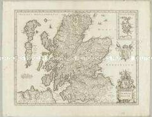
Regionalkarte
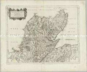
Novissima Regni Scotiae Septentrionalis et Meridionalis Tabula. Mit einer Nebenkarte: Orcades Insulae
- Alternative title
-
Novissima / REGNI / SCOTIAE / Septentrionalis et Meridionalis
- Location
-
Deutsches Historisches Museum, Berlin
- Inventory number
-
Do 2006/279
- Measurements
-
Höhe x Breite: 53,5 x 66 cm (Blatt)
Höhe x Breite: 48,5 x 57,3 cm (Karte)
Höhe x Breite: 50,5 x 60 cm (Platte)
- Material/Technique
-
Druckfarbe, Papier, Kupferstich
- Classification
-
Kartografie (Gattung)
- Subject (what)
-
Schottland
- Event
-
Herstellung
- (who)
-
Geograph, Verleger: Carel Allard
- (where)
-
Amsterdam, Niederlande
- (when)
-
um 1720
- Rights
-
Deutsches Historisches Museum
- Last update
-
24.03.2023, 9:28 AM CET
Data provider
This object is provided by:
Stiftung Deutsches Historisches Museum. If you have any questions about the object, please contact the data provider.
Stiftung Deutsches Historisches Museum. If you have any questions about the object, please contact the data provider.
Object type
- Regionalkarte
Associated
- Geograph, Verleger: Carel Allard
Time of origin
- um 1720
Other Objects (12)
Extima Scotiae Septentrionalis Ora
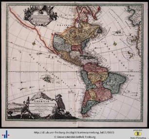
Totius Americae septentrionalis et meridionalis.
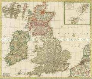
Nova Totius Angliae Scotiae Et Hiberniae. Mit einer Nebenkarte: Orcades Insulae borealiores

America septentrionalis novissima.- America meridionalis accuratissima
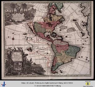
Novus Orbis sive America meridionalis et septentrionalis.
Totius America septentrionalis at meridionalis novissima repraesentatio...
Novissima Regni Scotiae Septentrionalis et Meridionalis Tabula Auctore Petro Schenk Karte des Königreichs Schottland Zeichner: Petrus Schenck, Amsterdam

Magnae Britanniae Pars Septentrionalis qua Regnum Scotiae
Großbritannien "MAGNAE BRITTANNIAE PARS SEPTENTRIONALIS QUA REGNUM SCOTIAE..."
Scotia Regnum. Mit einer Nebenkarte: Orcades Insulae.

Liber Primus. In Quo Ventorum in microcosmo septentrionalis et meridionalis afflatus...
![Totius Americae Septentrionalis Et Meridionalis Novissima Repraesentatio : quam ex singulis recentium Geographorum Tabulis collecta[m]](https://iiif.deutsche-digitale-bibliothek.de/image/2/d5c322af-7c3e-4e3f-87e8-38c6b134a117/full/!306,450/0/default.jpg)
Totius Americae Septentrionalis Et Meridionalis Novissima Repraesentatio : quam ex singulis recentium Geographorum Tabulis collecta[m]
Extima Scotiae Septentrionalis Ora
Totius Americae septentrionalis et meridionalis.
Nova Totius Angliae Scotiae Et Hiberniae. Mit einer Nebenkarte: Orcades Insulae borealiores
America septentrionalis novissima.- America meridionalis accuratissima
Novus Orbis sive America meridionalis et septentrionalis.
Totius America septentrionalis at meridionalis novissima repraesentatio...
Novissima Regni Scotiae Septentrionalis et Meridionalis Tabula Auctore Petro Schenk Karte des Königreichs Schottland Zeichner: Petrus Schenck, Amsterdam
Magnae Britanniae Pars Septentrionalis qua Regnum Scotiae
Großbritannien "MAGNAE BRITTANNIAE PARS SEPTENTRIONALIS QUA REGNUM SCOTIAE..."
Scotia Regnum. Mit einer Nebenkarte: Orcades Insulae.
Liber Primus. In Quo Ventorum in microcosmo septentrionalis et meridionalis afflatus...